Hourly Flood Simulation Across America: Beyond Traditional and Neural Network Models ✛
Context
Floods that kill and destroy often develop within hours of a downpour, even in places without stream gauges. A forecast useful for warnings must be accurate at peaks, reliable for rare events, and cover the entire river network, not just observation points. Alongside this work in the archive are studies on neural networks that hear the 'ocean's whisper' months before a storm, a digital grinder for double gravitational lenses, and a translator that learned the language of the ocean, but all of them tackle problems in other environments. In hydrology, neighboring works follow the line of distributed models with parameter learning: LSTM-RAPID, DROP, LSTM-TRoute, RiverMamba, and the δHBV series. However, all of them either operate on a daily step, lack explicit routing, or do not include infiltration excess, which is critical for fast peaks.
Methods
The δHBV2.0MTS-MC model is a differentiable distributed system for runoff generation and routing. It uses a multiscale structure: first, a daily HBV model runs for 351 days to initialize states of snow, soil moisture, and groundwater reservoirs; then these states are passed to an hourly HBV model that computes runoff for each of the 800,000 elementary basins. Fast saturated flow and an infiltration excess module are added (when rain is more intense than the soil can absorb). Routing is performed with the explicit Muskingum-Cunge method along the Hydrofabric river network, with a median elementary area of 7.2 km². All parameters are generated by neural networks that take static attributes of basins and river reaches; training is end-to-end, with gradients flowing from the error at stream gauges through routing and runoff generation to the parameters. Training on a single A100 GPU took about five days, and a 10-year simulation of the entire network took about four hours.
Results
Across 2831 gauges in the continental United States, the median hourly Nash–Sutcliffe efficiency (NSE) was 0.683, compared to 0.461 for the operational National Water Model NWM3.0 and 0.359 for the purely neural network LSTM-TRoute. The median Kling–Gupta efficiency (KGE) rose to 0.719, and the absolute bias dropped to 10.24%. For peaks with return periods of 100 years or more, the model reduces peak magnitude error by 34% compared to MTS-LSTM. The model captures 33% more floods with return periods of 50 years or more than NWM3.0, and 159% more than LSTM-TRoute, under strict criteria: magnitude error no more than 20% and timing error no more than 3 hours. The median peak timing error dropped from 7–8 hours for NWM3.0 to 4.5–6 hours. On small CAMELS basins, the model achieves a median NSE of about 0.710, surpassing NWM3.0 (0.545) and comparable to purely neural network MTS-LSTM and MF-LSTM, but with notably smaller errors in high flows. Ablation tests showed that multiscale initialization raises NSE from 0.643 to 0.710 and reduces low-flow error from 69.27% to 51.37%; the infiltration excess module barely changes aggregate metrics but reduces peak errors across all return period classes; dynamic Muskingum-Cunge routing on large basins (area greater than 10,000 km²) reduces the median peak magnitude error from 40% to 32.5% compared to a fixed unit hydrograph.
Implications
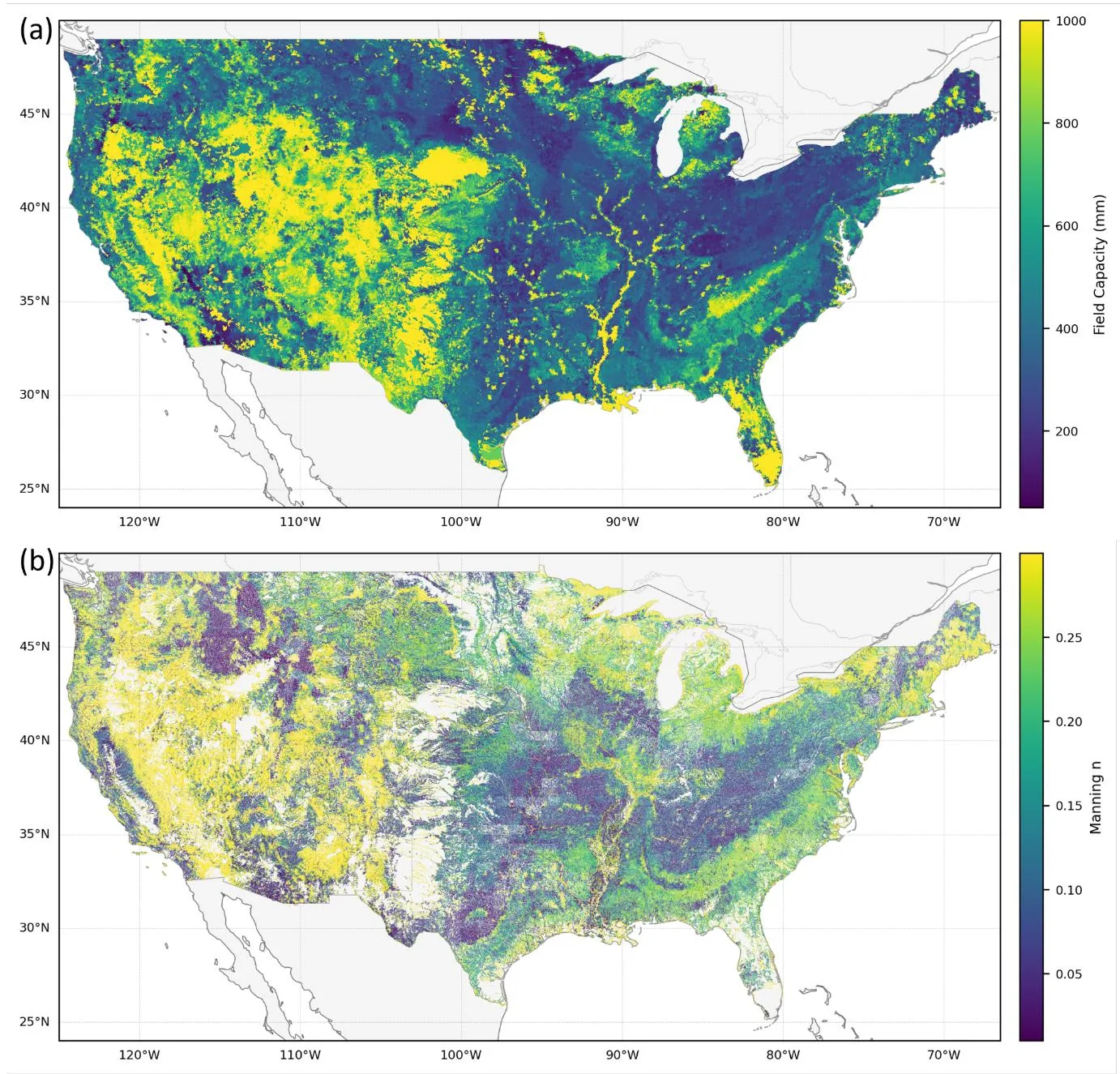
This work stands apart from its neighbors: the closest studies in the archive concern neural networks for the ocean, gravitational lenses, and weather, but not hourly floods on a continental scale. Within hydrology, it differs from previous distributed models by being the first to combine multiscale initialization, fast infiltration excess, and explicit routing in a single differentiable system trained on large data. This is not just an improvement in metrics but a shift in capabilities: the model produces physically interpretable parameters (such as field capacity and Manning's roughness) for each of the 800,000 river reaches, which purely neural network counterparts cannot provide. Such parameter fields previously required years of manual calibration, but now they are generated in minutes.
Future development
The topic could evolve toward incorporating reservoir operations, water withdrawals, and floodplain storage, which is critical for the largest river systems. Another direction is improving the quality of meteorological data, especially in arid and snow-dominated basins, where the model is still weaker. Smart ensembles and probabilistic forecasting based on learned parameters are likely to emerge, as well as real-time data assimilation.
Impact
The model could directly replace or complement the US National Water Model in operational flood warning systems. Its ability to produce hourly discharge for every river reach is useful for reservoir management, risk assessment, and responding to flash floods in ungauged areas.
Next steps
Immediate next steps include testing the model on basins larger than 50,000 km², where training has not yet been conducted. Experiments with withholding stream gauges from training are also needed to assess accuracy in truly ungauged locations.
Key open problems
In hydrology, the open question remains the reliable forecasting of rare floods under a changing climate, where historical data do not reflect future extremes. This work shows that hybrid models with physical constraints are more robust than purely neural network ones when extrapolating to unprecedented peaks, but the problem of accuracy in arid and snow-dominated basins remains unresolved.
The knowledge machine's view
This section is addressed to the author of the paper and their colleagues. Neighbouring works were found by meaning-based search across our archive, not by word overlap. We do not review: we show the field around the work.
What the work does
The work presents a distributed model, δHBV2.0MTS-MC, for hourly flood forecasting across the entire continental United States. The model combines multiscale runoff generation (daily initialization and hourly computation) with explicit routing along the river network, is trained end-to-end on data from 2831 gauges, and achieves a median NSE of 0.683, outperforming the operational NWM3.0 and a neural-network baseline, especially for rare extreme floods.
Where its strength is
Its strength lies in a differentiable distributed architecture with explicit routing and an infiltration-excess module, which allows for more accurate reproduction of rapid peaks and rare floods while preserving physical interpretability.
Where it could go next
- It might be interesting to see how methods from the work on joint modeling of water and electricity in a city can help link river runoff with other components of urban infrastructure, extending the model to anthropogenic impacts.based on: A City as a Single Organism: Water and Electricity Breathe in Unison arXiv:1902.10697
- A related work describes a neural network that captured the connection between the ocean and river runoff; perhaps using large-scale climate predictors as additional input data will improve forecasts at long lead times.based on: The Ocean Conducts the Rivers: How a Neural Network Heard the Whole Orchestra, Not Just the First Violin arXiv:2201.02596
- Ideas from the work on monthly weather forecasting may suggest ways to account for uncertainty and an ensemble approach for probabilistic flood forecasts.based on: A Month Ahead: What Machine Learning Can Do for Weather Forecasts arXiv:2006.07972
Worth trying
- Test adding urban water flows and water withdrawals to the model, using approaches from 1902.10697.
- Check whether incorporating ocean variability indices (for example, from 2201.02596) improves forecast accuracy on a seasonal scale.
- Build an ensemble version of the model with uncertainty estimation, inspired by methods from 2006.07972.
Why this may matter
Improving hourly flood forecasts at the continental scale with explicit routing and physically grounded components can enhance warning accuracy and reduce damage from flash floods, especially in poorly gauged regions.
Nearby works in our archive
- Predicting El Niño Six Months Aheadsimilarity 0.55
- The Ocean as a Patient: Neural Network Diagnoses Two Years Aheadsimilarity 0.54
- El Niño Can Be Predicted a Year and a Half in Advancesimilarity 0.53
- A City as a Single Organism: Water and Electricity Breathe in Unisonsimilarity 0.53
- A Translator That Learned the Language of the Oceansimilarity 0.52
- Learning from Many Brainssimilarity 0.52
- The Ocean Conducts the Rivers: How a Neural Network Heard the Whole Orchestra, Not Just the First Violinsimilarity 0.52
- A Month Ahead: What Machine Learning Can Do for Weather Forecastssimilarity 0.51
The archive is sparse around this work: the closest review is only 0.55, against a usual 0.64. It looks like few have drilled nearby.
Training the entire model for the continental United States took about five days on a single A100 GPU, and simulating 10 years of hourly streamflow for more than 800,000 river reaches took only about four hours on the same GPU. This is orders of magnitude faster than traditional calibration of distributed models, which could take years.
In Kim Stanley Robinson's novel 'The Ministry for the Future', a global system for predicting climate disasters warns of floods hours before they strike. The δHBV2.0MTS-MC model is a step toward such a system: it covers the entire river network of a country and provides forecasts every hour, enabling warnings about flash floods in ungauged places.
Key numbers
- median hourly NSE: 0.683
- median hourly NSE for NWM3.0: 0.461
- number of river reaches: 800,000+
- median elementary basin area: 7.2 km²
- reduction in peak timing error: from 7–8 hours to 4.5–6 hours