Hybrid Model Predicts El Niño Months Ahead ✛
Context
Forecasting weather beyond 7–10 days remains a challenge: traditional physics-based models suffer from systematic errors, while purely machine learning approaches have yet to prove reliable on seasonal timescales. This problem has spawned an entire research area: some groups improve climate models with neural networks, others try to predict El Niño a year and a half in advance, and still others refine hurricane forecasts. This work follows the same vein but bets on a hybrid approach: physics provides the framework, and machine learning corrects errors and adds missing variables.
Methods
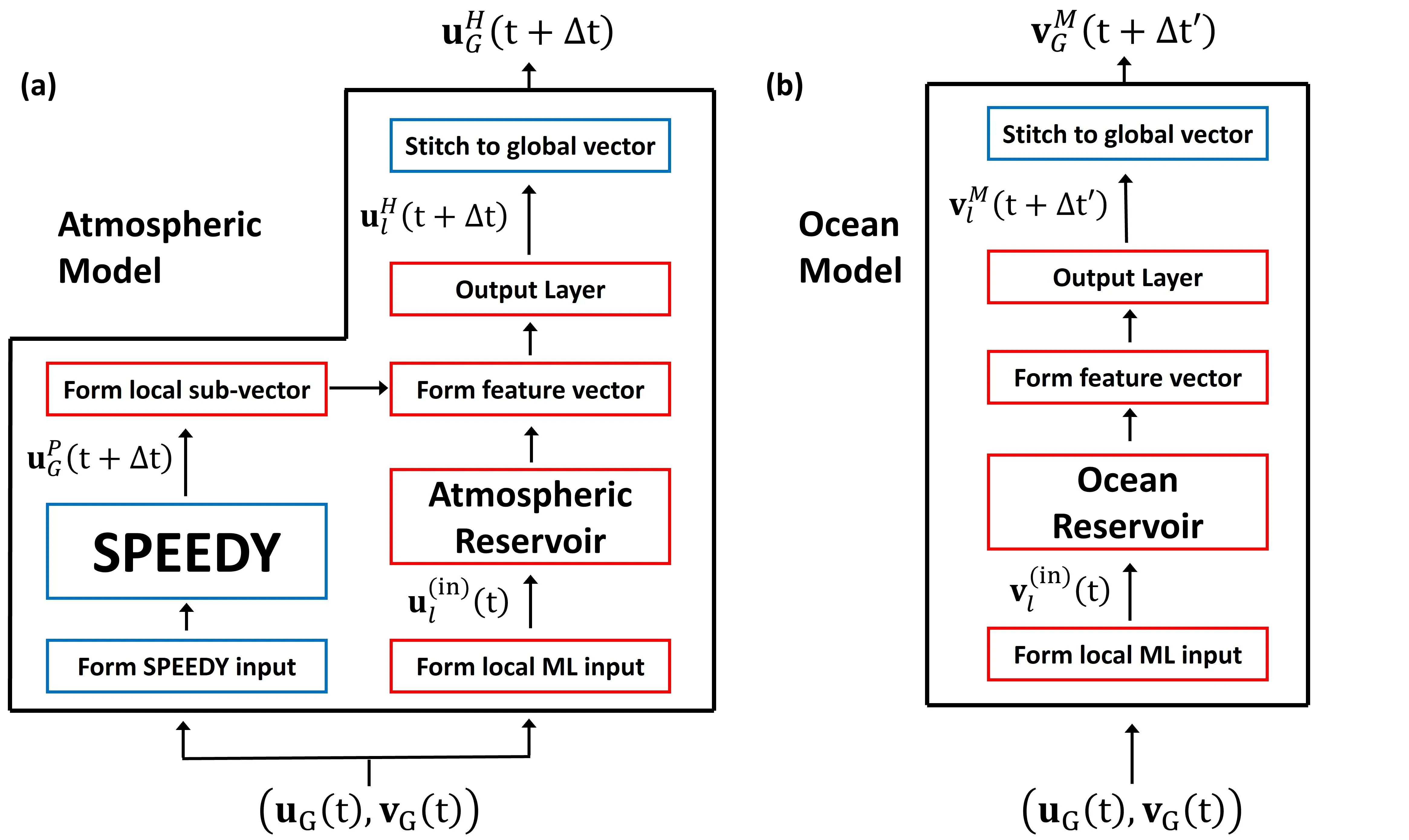
At its core is SPEEDY, a simplified atmospheric general circulation model with a horizontal resolution of 3.75° and eight vertical levels. Its prognostic variables are corrected by local reservoir computers trained on ERA5 reanalysis data from 1981 to 2002. The ocean component is purely machine learning: it predicts sea surface temperature and the new variable, upper-ocean heat content down to 300 meters. The atmospheric and oceanic components run on different time steps, 6 hours and 72 hours respectively, allowing the model to capture processes at different scales.
Results
The model forecasts the Niño 3.4 index (the average sea surface temperature anomaly in the central Pacific) better than the North American Multi-Model Ensemble (NMME) models over the first 4 months of the forecast, and in terms of root mean square error, up to 8.5 months. The Pearson correlation coefficient drops to 0.5 after about 6.5 months, with the predictability horizon varying from 4 months in spring to 8 months in late summer and early autumn, a manifestation of the so-called 'spring predictability barrier'. The model also reproduces global correlations between El Niño and rainfall: dry conditions in the eastern Pacific and over the Maritime Continent, and wet conditions in the southern United States. In the tropics, rainfall anomaly forecasts remain useful for 15 days in the eastern Pacific and 11.5 days in the western Pacific. Spectral analysis shows that the model maintains Kelvin and Rossby wave activity, as well as the Madden–Julian oscillation, throughout the two-year forecast.
Implications
This work demonstrates that a hybrid approach can compete with expensive operational models at a fraction of the computational cost. Unlike neighboring studies that either improve individual components of climate models or build purely machine learning forecasts, this one unifies a physical framework and machine learning into a single system that performs stably on seasonal timescales. That paves the way for accessible tools for academic groups and operational centers.
Future development
One could add machine-learned prognostic variables for land and the cryosphere to better capture two-way interactions between the atmosphere and other components of the Earth system. The precipitation variable should be trained on satellite data, such as IMERG, rather than only on ERA5 reanalysis. Moving to ensemble forecasts would reduce errors and provide uncertainty estimates, which is critical for subseasonal and seasonal predictions.
Impact
The results could influence operational weather forecasting, climate modeling, and El Niño research. The hybrid approach is also useful for educational purposes and small research groups without access to supercomputers.
Next steps
Test the model in ensemble mode and compare it with operational ensembles on subseasonal timescales. Explore adding land and sea ice variables to improve long-range forecasts.
Key open problems
This work directly addresses the 'spring predictability barrier' of El Niño, a sharp drop in forecast accuracy for forecasts initiated in spring. Adding upper-ocean heat content partially alleviates this barrier but does not eliminate it. The question remains open as to which other variables or processes need to be included to extend the predictability horizon during spring months.
The knowledge machine's view
This section is addressed to the author of the paper and their colleagues. Neighbouring works were found by meaning-based search across our archive, not by word overlap. We do not review: we show the field around the work.
What the work does
This study builds a hybrid atmosphere-ocean model: the SPEEDY physical core is corrected by reservoir computers trained on the ERA5 reanalysis, while the oceanic component predicts sea surface temperature and the heat content of the upper 300 meters. The model forecasts the Niño 3.4 index 3–7 months ahead, outperforming NMME in the first 4 months and in RMSE up to 8.5 months, and it reproduces the global teleconnections of El Niño with precipitation and equatorial wave activity in two-year forecasts.
Where its strength is
A successful combination of a cheap physical core and machine-based error correction, yielding competitive seasonal forecasts at computational costs orders of magnitude lower than traditional models. Introducing upper-ocean heat content as a prognostic variable is a concrete step that can be transferred to other hybrid systems.
Where it could go next
- It might be interesting to see how the hybrid correction approach transfers to drought forecasting: nearby in the archive is a study where a neural network, reading weather backward, warns of drought months in advance. Adding ocean heat content and reservoir computers could strengthen such forecasts in El Niño-sensitive regions.based on: How a neural network, reading weather backwards, warns of drought months in advance arXiv:2607.00331
- Nearby is an analysis of a model that predicts El Niño a year and a half ahead. It would be curious to compare which variables and architectures are used there to overcome the spring predictability barrier, and whether combining them with your hybrid approach could extend the forecast horizon.based on: El Niño Can Be Predicted a Year and a Half in Advance arXiv:2601.12251
Worth trying
- Test whether adding salinity anomalies or thermocline depth from the reanalysis to the oceanic component improves the forecast.
- Train the reservoir computers on a longer ERA5 period (up to 2023) to capture recent strong El Niño events.
- Evaluate how the model reproduces extreme precipitation during El Niño in specific regions (e.g., California or Australia) compared to NMME.
Why this may matter
If such a cheap hybrid can be extended to forecasting droughts and other regional impacts of El Niño, it would give academic groups and operational centers a tool for early warning without access to supercomputers.
Nearby works in our archive
- Weather forecast on a single GPUsimilarity 0.57
- El Niño Can Be Predicted a Year and a Half in Advancesimilarity 0.55
- Cloud Spices: How a Neural Network Improves Climatesimilarity 0.53
- Neural Network Charts a Precise Gravitational Map of Galaxiessimilarity 0.51
- Tropical Blueprint: A Neural Network Learns from an Algebraic Skeletonsimilarity 0.51
- Neural Network Sculptor: Reading a Gravitational Lens from Four Pointssimilarity 0.51
- How a neural network, reading weather backwards, warns of drought months in advancesimilarity 0.51
The archive is sparse around this work: the closest review is only 0.57, against a usual 0.64. It looks like few have drilled nearby.
The ocean component of the model takes a step every 72 hours, while the atmosphere steps every 6 hours. To synchronize them, the ocean simply 'freezes' for 12 atmospheric steps until its turn to update comes around.
The idea of a hybrid model where physics and machine learning work in tandem recalls the concept of 'neuromorphic' systems from science fiction, such as in Neal Stephenson's novel 'Seveneves', where autonomous modules of a spacecraft combine rigid algorithms with learnable components for long-term forecasting.
Key numbers
- atmospheric model resolution: 3.75° horizontal, 8 vertical levels
- atmospheric component time step: 6 hours
- oceanic component time step: 72 hours
- El Niño forecast horizon: 3–7 months depending on season
- tropical rainfall forecast horizon: 11.5–15 days