Sumatra's Cyclone Factory: A Decade of Observations
Context
The question of how mountains generate vortices has been in atmospheric science since the late 1980s, when the first numerical models showed that a flow blocked by a ridge leaves persistent cyclonic disturbances behind it. For the Indian Ocean, this idea was revived after the DYNAMO campaign of 2011–2012, when a vortex observed near the northern tip of Sumatra developed into a tropical cyclone within four days. A previous study based on 2.5 years of data pointed to four 'hot spots' off the coasts of Sumatra, the Malay Peninsula, and Java, but it remained unclear how typical those findings were over a longer period. The present study fills that gap using a ten-year ERA5 reanalysis record.
Methods
ERA5 reanalysis data for 2008–2017 were used, with a horizontal resolution of 0.25° and a temporal step of 6 hours. Vortices were identified using a feature-tracking algorithm based on relative vorticity averaged over the 850–925 hPa layer. A vortex was considered 'shed' if its final position was more than 500 km from Sumatra, or its displacement from the island exceeded 250 km, or its mean separation speed was above 0.5 m/s. Additionally, the phases of the Madden–Julian oscillation (using the RMM index with amplitude greater than 1), El Niño indices (MEI.v2), and the Indian Ocean Dipole were analyzed, along with tropical cyclone data from the JTWC archive.
Results
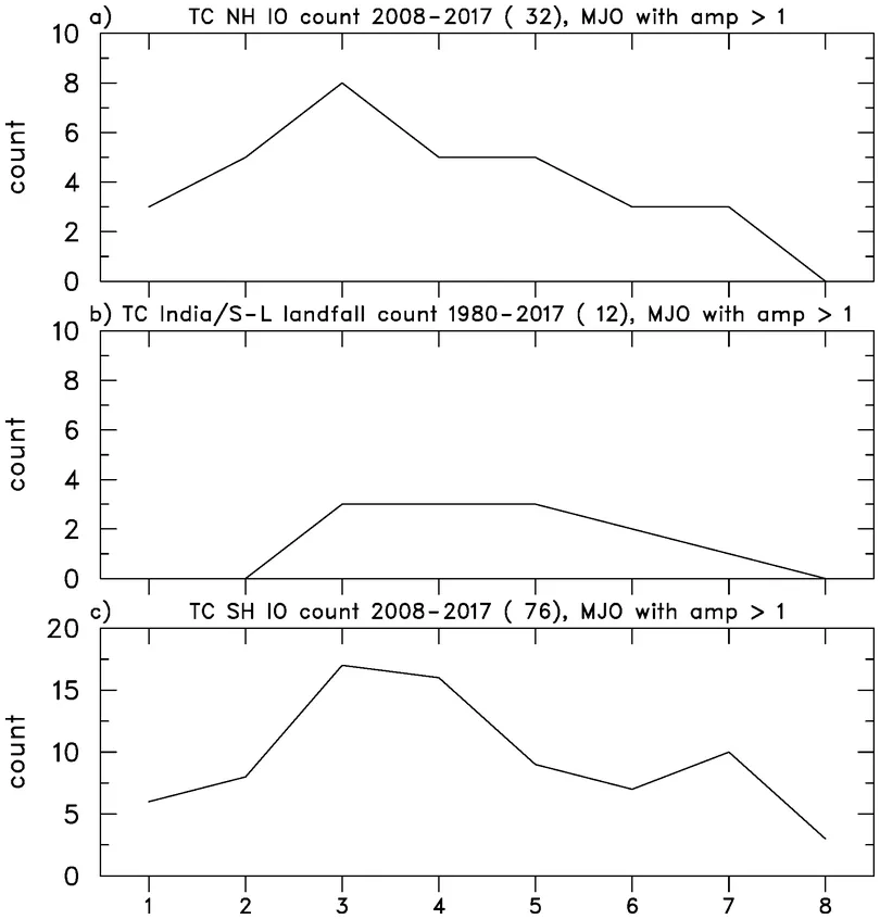
Over ten years, 1141 vortices formed in the four 'hot spots', of which 498 shed from the generating land. About 70% of all vortices and 80% of shed vortices occurred during easterly winds at the 925 hPa level. The largest number of vortices was recorded off Java (326), and the smallest off northern Sumatra (248). The annual cycle of vortex formation is closely tied to the seasonal wind shift: the maximum occurs in January–February in northern regions and in July–August in southern ones. The connection with the MJO phase was significant: the peak number of vortices occurs in phase 1 during strong easterly winds, with a secondary peak in phase 4, when westerly winds intensify near the equator west of Sumatra. At Sumatra's southern tip, anomalously easterly winds produced on average 4 vortices per month versus 1.1 during anomalously westerly winds, a fourfold difference. The correlation of vortex counts with ENSO and IOD indices is weak (r < 0.1) in almost all regions except southern Sumatra, where r = 0.36 for ENSO and 0.21 for IOD.
Implications
The study confirms that conclusions drawn from a short period generally hold for a ten-year record, but with important refinements. Unlike neighboring studies that focused on individual events or short campaigns, this work provides, for the first time, statistics of vortex formation over a full decade and demonstrates its connection to large-scale oscillations. The result for southern Sumatra proved especially valuable: there, wind anomalies linked to El Niño and the Indian Ocean Dipole most noticeably alter vortex frequency. This suggests that regional topographic features and local wind regimes may influence cyclone genesis more strongly than previously thought.
Future development
A natural next step is to extend the analysis period to all years of available ERA5 reanalysis, that is, from 1979. This would test the robustness of the found relationships over longer climatic fluctuations. Of particular interest is why wind anomalies at southern Sumatra so strongly affect vortex numbers, and what other factors besides zonal wind control vortex shedding. It may be necessary to track vortices with a lower vorticity threshold so as not to miss those that temporarily weaken and then intensify again.
Impact
The results directly bear on tropical cyclone forecasting in the Indian Ocean, especially for the coasts of India and Sri Lanka, which regularly suffer from such storms. Understanding how MJO phases and wind anomalies modulate vortex genesis could improve seasonal and intraseasonal forecasts of cyclonic activity.
Next steps
In the authors' immediate plans is to determine what fraction of shed vortices from 2008–2017 actually developed into tropical cyclones, and how many of those reached the shores of India and Sri Lanka. This will require modifying the tracking algorithm to avoid missing vortices that temporarily lose intensity.
Key open problems
The study touches on a fundamental problem in atmospheric dynamics: how mesoscale disturbances generated by topography interact with large-scale circulation and lead to the formation of hazardous weather systems. The physical mechanism that makes southern Sumatra so sensitive to wind anomalies remains an open question, as does why vortex shedding is not always determined solely by the strength of the easterly flow.
Sumatra straddles the equator, and its mountains in places exceed 3000 meters. It is the only major island that lies directly on the equator and yet has such high terrain capable of blocking the trade winds.
Key numbers
- number of vortices over 10 years: 1141
- share of vortices during easterly winds: about 70%
- share of shed vortices during easterly winds: about 80%
- increase in vortex count during anomalously easterly winds off southern Sumatra: 4 times
- correlation of vortex count with ENSO off southern Sumatra: 0.36