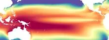
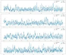
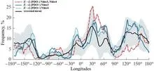
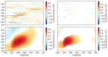
A week or so of westerly wind anomalies over the western equatorial Pacific, where the trade winds normally blow from the east. Here: at least two sigma above normal for five days or longer, averaged over six points between 130°E and 180°.
A westerly wind burst is a sudden, short-lived episode in which winds over the western equatorial Pacific blow from the west instead of the usual easterly trade winds. These bursts typically last about a week and can be quite strong. They are important because they can push warm surface water eastward along the equator, which is one of the triggers for El Niño events.
History
The term came into use in the 1980s as researchers studying El Niño recognized these wind events as key precursors. The specific operational definition — at least two standard deviations above normal for five days or longer — was later adopted for consistent detection in climate data.
How it works
Normally, trade winds blow from east to west across the tropical Pacific, piling up warm water in the western basin. When a westerly wind burst occurs, it temporarily reverses this flow, sending a pulse of warm water eastward. This can excite oceanic waves that travel along the equator and eventually warm the eastern Pacific, setting the stage for an El Niño. The bursts are often associated with atmospheric convection and can be triggered by weather systems like the Madden–Julian Oscillation.
In practice
Monitoring westerly wind bursts helps scientists forecast El Niño events months in advance, which is crucial for agriculture, water management, and disaster preparedness in many regions.
Fun fact
A single strong westerly wind burst can shift enough warm water to raise sea levels in the eastern Pacific by several centimeters.
A balloon that lets out air in bursts zips around the room — the jet blasts first one way, then another. A dying star behaves the same way as it sheds its bloated shell. Only instead of air, it's superheated gas, and instead of a balloon, it's a future white dwarf (the dense stellar remnant about the size of Earth).
The cosmic detective story began with a quiet flash in the optical band. AT2019wzc slowly brightened and faded like a smoldering ember. But hidden inside was something more energetic — repeating soft X-ray bursts that astronomers call quasi-periodic eruptions.
These eruptions last minutes to hours and repeat every few hours or days.
A disk of gas and dust spins around the young star HV Tau C, nearly edge-on to us. The James Webb Space Telescope examined its spectrum and detected the glow of hot molecular hydrogen (H₂). This revealed a wide, bipolar wind blasting from the inner regions far beyond the disk.
On March 26, 2026, the Chinese-European Einstein Probe observatory caught an X-ray flash that lasted a little over a quarter of an hour. A thousand seconds. The onboard WXT telescope registered a sharp rise in radiation, then a smooth decline, as if someone had screamed into silence, and the echo slowly faded.
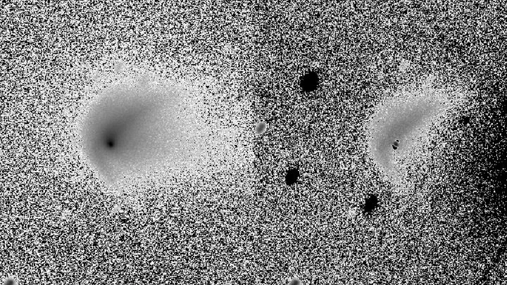
In the summer of 2021, comet 7P/Pons-Winnecke put on quite a show. A network of telescopes, the Las Cumbres Observatory, tracked it for nearly three months and counted eight sudden outbursts.
In 1991, Mount Pinatubo erupted with such force that it blanketed the planet in a thin veil of ash and gases for years. That veil, like a blanket on a hot night, trapped heat and cooled the ocean surface, causing tropical sea surface temperatures to dip. This event marks the start of a detective story about why some oceans are spawning ever more ferocious hurricanes while others remain calm.
Every winter, the tropical Pacific Ocean seems to replay the same script: sea surface temperatures off the coast of Peru rise, trade winds weaken, and a wave of droughts and floods spreads across the planet. This is El Niño, and its peak almost always falls in December. Why winter in particular?
The open ocean is a vast basin where almost no one measures the wind directly. Fixed platforms are rare and expensive, and satellite scatterometers, instruments that probe the surface with radar, need ground truth for calibration. Coastal zones have such data, but far from shore, there's a void.
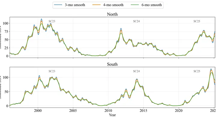
The Sun doesn't burn steadily: it erupts in series. Like a campfire that dies down and then suddenly throws out showers of sparks, these "fiery seasons" last from six months to a year and a half, and during them the star shows an unusually high number of sunspots.
Quarks are the tiny building blocks that make up protons and neutrons. Usually, they stick together in pairs: a particle and its mirror-image antiparticle. But sometimes quarks form more exotic combinations, which physicists call exotic states.
Two observers watch the Pacific Ocean. One studies surface heat maps, the other listens to the rhythm of temperature and heat stored in the water column. On their own, each notices only part of the picture, but together they can sense the approach of El Niño months before the warm current alters weather across the planet.
A black hole can torment a star for years, rather than rip it apart immediately. Tidal forces are when the hole's gravity stretches the star: the near side is pulled harder than the far side. Usually, getting too close rips the star apart instantly — that's a tidal disruption event.
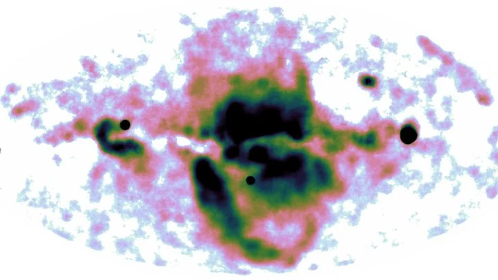
In 2020, the eROSITA X-ray telescope discovered a pair of enormous bubbles looming above and below the disk of our Galaxy. These clouds of gas heated to millions of degrees are the aftermath of a colossal energy release from the center.
In summer, the Arabian Sea breathes like a pair of bellows: one moment it pumps heat, the next it exhales moisture over a billion people. But sometimes this breathing stumbles, and the water off the coasts of India and Pakistan runs a few degrees hotter than usual.
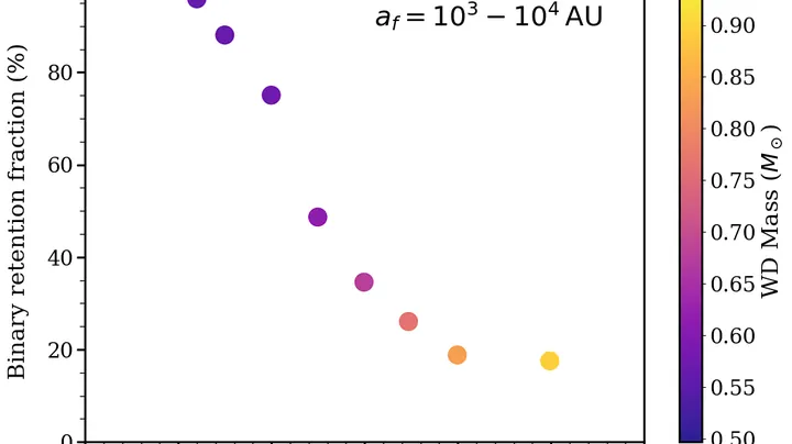
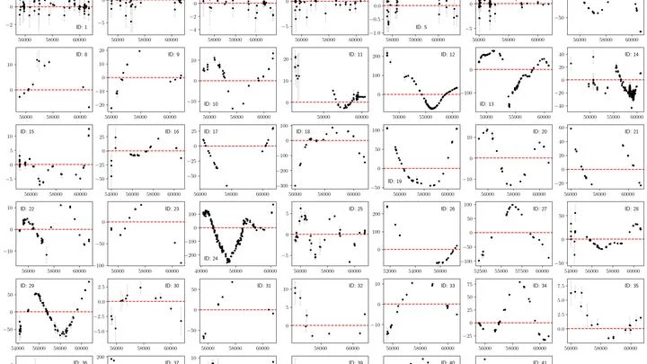
Eclipses in binary stars are like clockwork: a white dwarf (the dense remnant of a star) regularly passes in front of its companion, and the light briefly dims. But for most such pairs, the clock runs fast or slow by seconds over years. Astronomers measured these glitches in 43 systems and found a pattern.
The young star RY Tau is like a finicky spinning top. Around it whirls a flat disk of gas and dust — the leftovers of the cloud from which the star was born. The star pulls some of the disk's matter toward itself like a vacuum cleaner, and flings some back out in a narrow wind cone like a fountain.
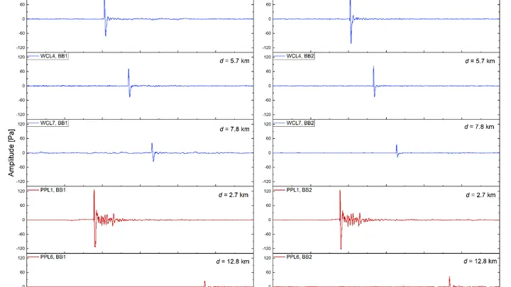
The same explosion can sound different: it all depends on which way the wind is blowing. In 2024, researchers set off charges equivalent to ten tons of TNT twice and recorded the sound with a network of 31 microphones spread over a radius of 23 kilometers. The source was identical, but the acoustic pictures turned out to be quite different.
Paraglider, hang glider, and glider — three different wings, but in the sky they behave the same. Pilots catch invisible warm air currents, rise on them, then glide to the next. Such flight is like a game of hopscotch: a jump upward, then a glide forward, and again a search for a place to jump.
Scientists analyzed thousands of real routes and found a common law.
The Pacific Ocean is like a giant swing: warm water piles up in the west, then slides toward the east, and the temperature off the coast of South America jumps. Such warm years are called El Niño, and cold ones La Niña. But the swing doesn't move on its own: it's pushed by the wind.
Every day, about 40,000 thunderstorms flash across the planet. In that moment, the atmosphere resembles an orchestra without sheet music: warm air rises like a bow stroke, winds aloft carry the melody, and lightning punctuates the finale. But who conducts this orchestra?
Two conductors stand before one orchestra. One waves the baton quickly, setting the tempo every few bars. The second is almost motionless, but his slow breathing changes the overall sound throughout the symphony. So it is in the tropical Pacific: one part of the wind governs the fast oscillations of El Niño, the other governs decadal climate shifts.
A magnetar's crust cracks in milliseconds. A deep shift generates seismic waves that run across the surface and shake the magnetic field. This starquake is like an earthquake, but on a neutron star with a field a quadrillion times stronger than Earth's.
An invisible relay race runs through Earth's tropics: a wave of heavy rain and winds, which meteorologists call the Madden–Julian Oscillation, travels eastward at about five meters per second. Most runners tire quickly, but rare marathoners carry the torch all the way across the Pacific.
In May 2024, thermometers in Jalisco seemed to go haywire: on May 10, one station recorded 38.4°C, nearly matching the historical maximum from 1994. The heat was so intense that even agave plants, accustomed to scorching conditions, slowed their growth. And the rains, which usually arrive in June, were delayed, leaving farmers nervously glancing at the sky.
You can sit on a seesaw and pump your legs, or you can just tip from one side to the other. The Pacific Ocean does both. Every few years, warm water off the coast of Peru gives way to cooler water, and rainfall patterns, winds, and entire ecosystems across half the planet reshuffle. These shifts are called El Niño and La Niña, together known as ENSO: Earth's climate seesaw.
An interpreter in a conference room hears not just words but intonations, pauses, and gestures. From these cues, they anticipate where the conversation will turn. The Pacific climate speaks the language of wind, heat, and currents, and PTSTnet listens like an experienced simultaneous interpreter, grasping the grammar of ocean and atmosphere.
The tropical Pacific breathes in two rhythms. One lasts several years: the water off the coast of Peru warms and cools, which fishermen call El Niño. The second rhythm is fast: every month or two, a giant cloud wave is born over the warm waters of the Indian and Pacific Oceans, creeping eastward at a runner's pace and dying out near South America.
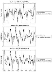
The ocean breathes, and hurricanes swing on its breath like on a seesaw. Over the past seventy years, hundreds of tropical cyclones have crossed the North Atlantic, and not all of them behaved alike. Some decades brought a barrage of destructive storms to coastlines; others brought calm.
Imagine an orchestra playing without a conductor. Each section takes its turn: first the winds introduce the theme, then the strings join in, and sometimes an unexpected percussionist solos.
The Pacific Ocean behaves like a conductor setting the tempo for outages in the American power grid. When the ocean shifts into its cold phase, known as La Niña, lights start going out more often across the US. Researchers traced this connection over 24 years and confirmed that the ocean really does drive the weather, and the weather batters wires and transformers.
When the Pacific off the coast of Peru heats up, the planet's familiar weather map goes haywire: droughts in some places, floods in others. That's El Niño, and it costs the global economy trillions of dollars. Scientists have long been able to predict it, but now, for the first time, they are testing whether it can be weakened while it's still developing.
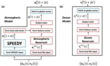
A translator at an important negotiation starts by simply repeating words, but gradually begins to anticipate what the counterpart will say. The new weather model works similarly: physics provides the framework, and machine learning learns from errors and fills in the gaps.
Every few years, the Pacific Ocean changes its character. Sometimes it warms up off the coast of South America, which is called El Niño, and sometimes it cools down, bringing La Niña. For someone on the other side of the planet, this is not just a weather report item. The ocean acts as a conductor, setting the tempo for heat and drought over Eurasia.
The Pacific Ocean breathes, and that breath has a pulse. Every few years, its surface warms more than usual, bringing torrential rains to Peru and drought to Australia. This is El Niño, the warm phase of the ocean temperature oscillation.
Every year, over the semi-arid belt south of the Sahara, the sky stages the same play: gentle rains that nourish millet, and violent downpours that wash away villages. Until recently, both acts were attributed to a single conductor: ocean surface temperature. But if you listen closely, each rain has its own control panel.
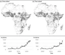
On an African field, maize has just been harvested. The grain sits in sacks, and for armed groups it's a lure: something to take from farmers. But if the harvest fails, the lure disappears, and attacks become fewer. That's exactly what happens when El Niño (the warm current in the Pacific Ocean that alters weather worldwide) brings drought to Africa's farming regions.
In the mountains, an echo repeats any shout, and you can't immediately tell who shouted: a person or the wind. That's roughly how climate scientists work when they try to understand why an unusual heat wave or drought happened. They look for a human fingerprint in a weather disaster, but nature has its own voices that can sound similar.
The Pacific Ocean is a vast pot of water that someone occasionally stirs, now at one edge, now at another. When warm water piles up off the coast of South America, fishermen call it El Niño, "the child," because it often arrives around Christmas.
In 1982, fishermen off the coast of Peru found their nets empty, while on the other side of the Pacific, in Australia, drought set in. That was the first time El Niño made itself loudly known: a warm current that, every few years, turns the world's weather upside down.
An interpreter at a negotiation hears not only the volume of the voice but also the shift in topic. Climatologists have long listened only to volume: the average temperature. If it rises, the planet is warming. But behind the average hide events that matter more than the trend: heat waves, cold snaps, sudden changes.