The Madden–Julian Oscillation (MJO) is a large-scale pattern of enhanced and suppressed rainfall that travels eastward around the globe near the equator, completing a full circuit in roughly 30 to 60 days. It is not a storm itself but a moving envelope of cloudiness and precipitation, often visible as a broad band of thunderstorms that slowly drifts from the Indian Ocean toward the Pacific. As it moves, it influences weather far beyond the tropics, modulating the intensity of monsoons, the frequency of tropical cyclones, and even the timing of mid-latitude storms.
History
The oscillation was discovered in 1971 by Roland Madden and Paul Julian, who noticed a 40–50 day periodicity in wind and pressure data from the tropical Pacific while analyzing weather station records at Canton Island and Singapore.
How it works
The MJO arises from the coupling between the ocean and the atmosphere. In its active phase, enhanced convection (rising air and cloud formation) heats the atmosphere, which in turn alters wind patterns. These winds affect the ocean surface, changing sea surface temperatures and moisture availability. The disturbance then propagates eastward because the atmospheric response to the heating creates new convection ahead of the existing one, while the region behind cools and dries. This cycle repeats, giving the oscillation its characteristic period. The MJO's phase can be tracked using indices based on outgoing longwave radiation and wind data.
In practice
Forecasters monitor the MJO to predict sub-seasonal weather patterns, such as the timing of monsoon breaks in India, the likelihood of tropical cyclone formation in the Atlantic, and the onset of El Niño events, as the MJO's westerly wind bursts can trigger El Niño development.
Fun fact
The MJO is so influential that its phase can shift the odds of a polar vortex disruption in the Arctic, sometimes leading to cold air outbreaks in North America and Europe weeks later.
A stone thrown into water quickly loses speed. A meteor entering the atmosphere should behave the same way: air slows it down, and friction burns up its material. But cameras of the Global Fireball Observatory network have captured hundreds of bright fireballs over ten years that streak across the sky with almost no deceleration.
Think of a merry-go-round: the farther you sit from the center, the faster you're carried around. For a long time, astronomers assumed galaxies work the same way — stars at the edges should orbit more slowly than those near the center. But back in the 1970s, it turned out that in many spiral galaxies, the speed of stars barely drops with distance from the center.
Jupiter's atmosphere resembles a layered cake, where each layer plays its role. Scientists took data from four instruments at once (VLT/MUSE, Cassini/VIMS, IRTF/SpeX, and Juno/JIRAM) and built a model of clouds and ammonia in the planet's equatorial zone, from 0.1 to 10 bar (pressure equivalent to hundreds of kilometers below Earth's…
Two galaxies (our Milky Way and its satellite, the Large Magellanic Cloud) slowly circle each other. Their gravitational pull stirs the distant outskirts of the Milky Way, like a pebble thrown into a pond makes the water ripple.
During a thunderstorm, the sky acts like a giant battery: charge builds up in the cloud, and a lightning bolt discharges it. That charge is invisible, but cosmic particles (muons, which constantly rain down on Earth from space) can sense it. As a muon flies through a charged cloud, it speeds up or slows down slightly, and these changes reveal the voltage inside the cloud.
Over the warm waters of the Indian Ocean, every six to eight weeks, a vast wave of moist air gathers. It moves eastward at a pedestrian pace—about five meters per second—and takes forty to ninety days to circle half the planet.
In summer, the Arabian Sea breathes like a pair of bellows: one moment it pumps heat, the next it exhales moisture over a billion people. But sometimes this breathing stumbles, and the water off the coasts of India and Pakistan runs a few degrees hotter than usual.
Above Jupiter's poles, auroras blaze as electrons are accelerated by electric fields and slam into the upper atmosphere, making the gas glow. But not all electrons head downward. Some, it turns out, get a kick in the opposite direction — away from the planet, into deep space.
An invisible relay race runs through Earth's tropics: a wave of heavy rain and winds, which meteorologists call the Madden–Julian Oscillation, travels eastward at about five meters per second. Most runners tire quickly, but rare marathoners carry the torch all the way across the Pacific.
The tropical Pacific Ocean lives in two rhythms. The first is fast: a wave of thunderstorms born over the Indian Ocean races eastward and dies out off the coast of the Americas within a month or two. The second is slow: every few years, the ocean surface warms enough to alter weather across the entire planet. That is El Niño. Between these rhythms lies a bridge, and building it took climatologists decades.
In May 2024, thermometers in Jalisco seemed to go haywire: on May 10, one station recorded 38.4°C, nearly matching the historical maximum from 1994. The heat was so intense that even agave plants, accustomed to scorching conditions, slowed their growth. And the rains, which usually arrive in June, were delayed, leaving farmers nervously glancing at the sky.
From July 2023 to July 2024, Earth's atmosphere gained carbon dioxide at a rate of 3.66 parts per million per year. That is the fastest pace since 1979. The reason is not that factories and cars suddenly started emitting more CO₂. The planet's lungs—forests and soils—took a shallower breath.
The planet breathes through its green cover.
Over the warm waters of the Indian and Pacific Oceans, a giant wave of moist air is born every month or two. It creeps eastward at a pedestrian pace, about five meters per second, dragging bands of downpours and droughts behind it. Meteorologists call it the Madden–Julian Oscillation MJO.
The tropical Pacific breathes in two rhythms. One lasts several years: the water off the coast of Peru warms and cools, which fishermen call El Niño. The second rhythm is fast: every month or two, a giant cloud wave is born over the warm waters of the Indian and Pacific Oceans, creeping eastward at a runner's pace and dying out near South America.
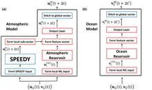
A translator at an important negotiation starts by simply repeating words, but gradually begins to anticipate what the counterpart will say. The new weather model works similarly: physics provides the framework, and machine learning learns from errors and fills in the gaps.
Sumatra's mountain range works like a stamping press: easterly winds hitting the slopes leave a chain of rotating imprints in the air behind the island. These vortices, like blanks on an assembly line, detach from the land and drift over the ocean, where some of them grow into tropical cyclones.
In 1884, British meteorologist Henry Blanford built the first model for forecasting the Indian monsoon. Nearly a century and a half later, seasonal forecast skill has barely improved.
Every summer, a giant atmospheric engine unfolds over India: moist ocean winds bring the rains that sustain crops and the lives of two billion people. But this engine sputters, and forecasting it a season ahead remains elusive. Models give only rough answers, and a monsoon forecast error can cost millions of tons of food.
Every few years, the Pacific Ocean off the coast of Peru warms up, and then fields dry out in Australia while deserts in Chile get drenched. This phenomenon is called El Niño.
Every clear night, a telescope on the island of La Palma looked at the sky and recorded how much the air dimmed starlight. This was routine work for astronomers measuring stellar positions. But in these records, like in an old diary, traces of a different story remained: the arrivals of dust from the Sahara.
A barometer on the island of Tahiti and a barometer in the Australian city of Darwin show different pressures. Subtract one from the other, and you get a number that climatologists call the Southern Oscillation Index. It changes every day, but within these daily jumps hide steady rhythms, just as the beats of a metronome hide within the noise of an orchestra.