Network Warns of El Niño a Year in Advance
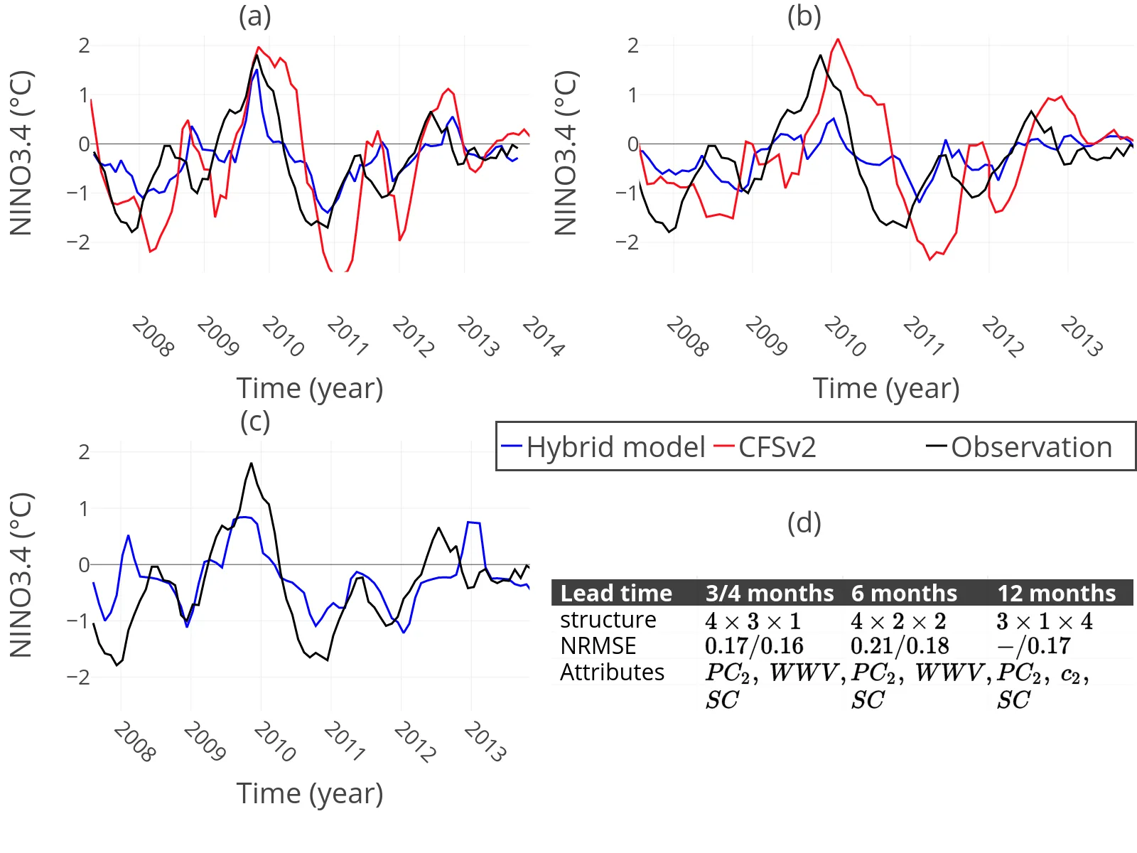
In 2010, the Pacific Ocean was brewing a strong El Niño, but all forecasting models collectively overestimated it. They looked at water temperatures and missed the key point: the ocean had already begun to reorganize, not loudly but quietly, linking distant points in pairs. El Niño is a warm tongue of water in the eastern Pacific that, every few years, alters weather from Australia to Peru. The problem is that forecasts go blind in spring: the so-called spring predictability barrier cuts the horizon to six months.
The new model listens not only to temperature but also to connections within the ocean. The scientists built a climate network: each point on the map is a node, and a link between points forms when their fluctuations coincide. It turns out that before El Niño, the ocean starts 'whispering' in pairs: the fraction of nodes with exactly one partner increases. This metric is called c2, and it starts rising a year before the event.
The model works in two steps. First, classical ARIMA statistics capture the linear part: seasonal cycles and inertia. Then a neural network learns the nonlinear deviations that statistics missed. The network is fed not only the NINO3.4 temperature index but also the volume of warm water, westerly wind bursts, and the sine of the annual cycle. For the 12-month forecast, they use c2 instead of warm water volume.
The result surprised even the authors. At lead times of 3–6 months, the hybrid model outperformed the CFSv2 ensemble forecast, which is considered the standard. In January 2010, all ensemble members overestimated the index, while the hybrid model gave the exact value. The forecast error at 4 months ahead was nearly a quarter lower. But the key finding: the 12-month forecast with c2 was as good as, and sometimes better than, the 6-month forecast. The average error for a year ahead was 0.018, and for six months, 0.017.
Perhaps the barrier was not a wall of chaos but simply a lack of information. Once we learned to hear the whisper of pairs, the ocean became predictable a year ahead. Now meteorological centers can warn of droughts and floods long before the ocean screams.
The network metric c2 is simply the fraction of nodes that form pairs. In the climate network, it increases when local correlations strengthen before El Niño and decreases afterward. In essence, the ocean starts 'whispering' in pairs before it screams.