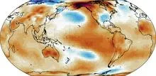
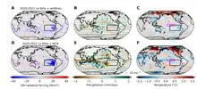
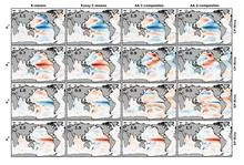
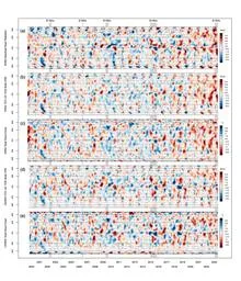
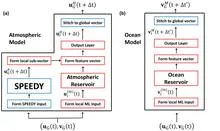
El Niño is a natural climate phenomenon in which the surface waters of the central and eastern tropical Pacific Ocean become unusually warm. This warming is not just a local event; it shifts atmospheric circulation patterns across the globe, altering rainfall, temperature, and storm tracks for months at a time. The name, Spanish for 'the boy child,' was coined by Peruvian fishermen who noticed warm currents around Christmas, but the phenomenon's influence extends far beyond South America, affecting weather in North America, Australia, Southeast Asia, and even Africa.
History
The term 'El Niño' has been used by Peruvian fishermen since at least the 19th century, but the global connection was recognized in the 1920s by Sir Gilbert Walker, who studied pressure oscillations across the Pacific. The full physical mechanism was clarified in the 1960s and 1970s by Jacob Bjerknes, who linked the ocean warming to atmospheric circulation changes.
How it works
Normally, trade winds blow from east to west across the tropical Pacific, pushing warm surface water toward Indonesia and allowing cooler, nutrient-rich water to upwell along South America. During El Niño, these trade winds weaken or even reverse. The warm water that usually piles up in the western Pacific sloshes back eastward, suppressing upwelling and leaving a vast expanse of warm water in the central and eastern Pacific. This warm water heats the atmosphere above it, shifting the location of thunderstorm activity and altering the jet streams, which in turn changes weather patterns worldwide.
In practice
El Niño forecasts are used by governments and industries to prepare for droughts, floods, and changes in agricultural yields, as well as by disaster management agencies to mitigate impacts on vulnerable regions.
Fun fact
El Niño can temporarily slow the rise of global average temperatures because the warm Pacific waters release heat into the atmosphere, but the effect is complex and not always in the same direction.
Two pendulums suspended from a single invisible spring swing in a shared air current. One always lags the other by exactly half a period: when the first swings left, the second is already returning from the right. By watching the first, you can tell where the second will be half a period later.
In 1991, Mount Pinatubo erupted with such force that it blanketed the planet in a thin veil of ash and gases for years. That veil, like a blanket on a hot night, trapped heat and cooled the ocean surface, causing tropical sea surface temperatures to dip. This event marks the start of a detective story about why some oceans are spawning ever more ferocious hurricanes while others remain calm.
In the Atlantic, a giant invisible conveyor operates: warm surface waters flow north, cool, sink, and return south. This circulation, AMOC, carries heat, making Europe noticeably milder than Canada at the same latitudes. But the conveyor isn't eternal: if diluted by fresh water from melting Greenland ice, the engine stalls.
Beyond Neptune, in the icy belt, astronomers watched as object (612533) 2002 XV93 momentarily occulted a distant star. Using метод прохождений (when a planet dims the star's light for a second, like a fly in front of a lamp), Уильям Боруки and Дэвид Шарбонно determined: the light not only dimmed but also shifted…
Two observers watch the Pacific Ocean. One studies surface heat maps, the other listens to the rhythm of temperature and heat stored in the water column. On their own, each notices only part of the picture, but together they can sense the approach of El Niño months before the warm current alters weather across the planet.
Over the warm waters of the Indian Ocean, every six to eight weeks, a vast wave of moist air gathers. It moves eastward at a pedestrian pace—about five meters per second—and takes forty to ninety days to circle half the planet.
In summer, the Arabian Sea breathes like a pair of bellows: one moment it pumps heat, the next it exhales moisture over a billion people. But sometimes this breathing stumbles, and the water off the coasts of India and Pakistan runs a few degrees hotter than usual.
The ocean does not shout about its intentions. It whispers: a warm patch off the coast of Peru, a cold tongue near Hudson Bay, a barely perceptible shift in a current. The atmosphere does not respond immediately, and by winter Europe may get either mild slush or Siberian frosts.
Two pendulums hang on the same wall, swinging out of sync, but suddenly they move as one, only with an 18-month delay. One pendulum is the Indian monsoon, the seasonal wind that brings rain to South Asian farmland. The other is the deep water of the tropical oceans, which slowly accumulates heat and remembers it for years.
Imagine a radiator in a room: it heats up, but if its surface is clogged with dust, heat escapes less efficiently. Something similar is happening to our planet. Earth receives energy from the Sun and must radiate the excess back into space, otherwise temperatures rise. Scientists call this ability to shed excess heat radiative feedback.
Glaciers don't just darken from soot. Their surfaces host tiny algae that, as temperatures rise, bloom and turn the ice dark. Dark ice absorbs more sunlight, melts faster, and further warms the planet. It's like how a black t-shirt in the sun gets hotter than a white one.
The second player in overheating is forests.
For a long time, the climate of ancient Mars remained a mystery: the beds of dried-up rivers spoke of water, but models couldn't explain how it got there — after all, 4 billion years ago the Sun shone 30% dimmer. New research shows that the planet swayed, as if on a swing, between long glaciations and short wet epochs.
Rain doesn't fall just any old way. If you take records from nearly fifty thousand rain gauges scattered across the globe and compare how much water falls on a rainy day in different parts of the planet, you'll spot a surprising pattern.
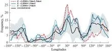
In 1997, the Pacific Ocean warmed so much that corals bleached from Indonesia to the Galápagos, and floods and droughts swept across five continents. Such events, which climate scientists call extreme El Niños, occur every few decades, and to understand how often they will arrive in the future, we need thousands of years of observations.
A warm ocean off the coast of Peru can make winter in Moscow unusually mild. Climate scientists call these invisible threads that link weather in distant corners of the planet teleconnections. For a long time, they were thought of as something like permanent wiring: the signal sources may pulse, but the wires themselves lie still.
The Pacific Ocean is like a giant swing: warm water piles up in the west, then slides toward the east, and the temperature off the coast of South America jumps. Such warm years are called El Niño, and cold ones La Niña. But the swing doesn't move on its own: it's pushed by the wind.
Every day, about 40,000 thunderstorms flash across the planet. In that moment, the atmosphere resembles an orchestra without sheet music: warm air rises like a bow stroke, winds aloft carry the melody, and lightning punctuates the finale. But who conducts this orchestra?
The orchestra assembled, the instruments were tuned, but there was barely any music: that's what the 2025 Atlantic hurricane season looked like. The ocean was the fifth warmest on record, and a weak La Niña usually adds strength to storms. But instead of a continuous concert, we got isolated thunderous chords: three Category 5 hurricanes, with silence in between.
Why was the orchestra silent?
The climate of the United States is not a straight line creeping upward. It is an orchestra without a conductor, where every violin and every drum plays its own part, and together they create an intricate pattern of warm and cold, wet and dry years.
A camera on a tripod shoots the same landscape for decades. If you don't touch the lens, the images get hazy: the landscape changes, but the focus stays put. That's roughly how climate norms work. According to World Meteorological Organization rules, they are calculated as the average over the last 30 years.
In summer, the South China Sea can show a strange pattern: the water in the north warms while the south cools at the same time. A year later, it's the opposite. This isn't random; it's a steady seesaw that the ocean rocks every summer.
An invisible relay race runs through Earth's tropics: a wave of heavy rain and winds, which meteorologists call the Madden–Julian Oscillation, travels eastward at about five meters per second. Most runners tire quickly, but rare marathoners carry the torch all the way across the Pacific.
In May 2024, thermometers in Jalisco seemed to go haywire: on May 10, one station recorded 38.4°C, nearly matching the historical maximum from 1994. The heat was so intense that even agave plants, accustomed to scorching conditions, slowed their growth. And the rains, which usually arrive in June, were delayed, leaving farmers nervously glancing at the sky.
Picture a pendulum hanging in a room with drafts. Sometimes a gust pushes it harder, sometimes softer. If the pendulum barely loses energy, it will swing long and steady. But if friction is strong, each push quickly fades, and the motion becomes jerky: a sharp swing, then a long sway. That's exactly how the tropical Pacific behaves when the heat of El Niño gives way to the cold of La Niña.
From July 2023 to July 2024, Earth's atmosphere gained carbon dioxide at a rate of 3.66 parts per million per year. That is the fastest pace since 1979. The reason is not that factories and cars suddenly started emitting more CO₂. The planet's lungs—forests and soils—took a shallower breath.
The planet breathes through its green cover.
In 2015, downpours in Chennai turned streets into rivers overnight. The city was caught unprepared: seasonal models offered only a vague warning. Yet the monsoon is not a whim of the sky; it is the pulse of a vast machine linking oceans and continents.
An interpreter at negotiations hears only the words already spoken, yet still guesses the next phrase. This is how the new El Niño forecasting method works: it doesn't peek into the future but relies solely on the past, like an honest listener.
Imagine an orchestra playing without a conductor. Each section takes its turn: first the winds introduce the theme, then the strings join in, and sometimes an unexpected percussionist solos.
Imagine an interpreter in a huge hall who hears not only the person next to them but also a whisper in the far corner, and from those fragments reconstructs the entire conversation. That's how the CAS-Canglong neural network works: it picks up connections between pressure, wind, and heat across the whole planet and uses them to predict what the ocean will look like three months from now.
The carbon cycle is like the planet's breathing. Forests and oceans inhale carbon dioxide, while industry and wildfires exhale it back. In 2023, that inhale became gasping and shallow. At the Mauna Loa station, instruments recorded that CO₂ concentrations rose by 3.37 parts per million over the year, 86% faster than the year before.
The Pacific Ocean behaves like a conductor setting the tempo for outages in the American power grid. When the ocean shifts into its cold phase, known as La Niña, lights start going out more often across the US. Researchers traced this connection over 24 years and confirmed that the ocean really does drive the weather, and the weather batters wires and transformers.
When the Pacific off the coast of Peru heats up, the planet's familiar weather map goes haywire: droughts in some places, floods in others. That's El Niño, and it costs the global economy trillions of dollars. Scientists have long been able to predict it, but now, for the first time, they are testing whether it can be weakened while it's still developing.
An artist painting the ocean does not limit themselves to two colors: warm and cold. Likewise, climatologists studying El Niño increasingly speak of a whole palette of shades. El Niño is a warm current off the coast of Peru that, every few years, alters weather across the planet. Its counterpart, La Niña, brings cold.
In the summer of 2023, thermometers around the world registered numbers that even the boldest forecasts had not anticipated. The planet's average temperature rose to 1.48°C above pre-industrial levels, a jump of 0.17°C that broke the previous record as if the climate had suddenly shifted gears.
A translator at an important negotiation starts by simply repeating words, but gradually begins to anticipate what the counterpart will say. The new weather model works similarly: physics provides the framework, and machine learning learns from errors and fills in the gaps.
Every few years, the Pacific Ocean changes its character. Sometimes it warms up off the coast of South America, which is called El Niño, and sometimes it cools down, bringing La Niña. For someone on the other side of the planet, this is not just a weather report item. The ocean acts as a conductor, setting the tempo for heat and drought over Eurasia.
The Pacific Ocean breathes, and that breath has a pulse. Every few years, its surface warms more than usual, bringing torrential rains to Peru and drought to Australia. This is El Niño, the warm phase of the ocean temperature oscillation.
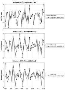
Every year, over the semi-arid belt south of the Sahara, the sky stages the same play: gentle rains that nourish millet, and violent downpours that wash away villages. Until recently, both acts were attributed to a single conductor: ocean surface temperature. But if you listen closely, each rain has its own control panel.
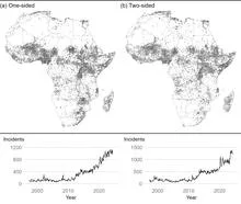
On an African field, maize has just been harvested. The grain sits in sacks, and for armed groups it's a lure: something to take from farmers. But if the harvest fails, the lure disappears, and attacks become fewer. That's exactly what happens when El Niño (the warm current in the Pacific Ocean that alters weather worldwide) brings drought to Africa's farming regions.
The Atacama Desert in northern Chile is the driest non-polar place on Earth. The sky is almost always clear, and the air is so devoid of moisture that even distant galaxies are visible without interference.