Europe's Hydrosphere Under GPS Surveillance: Slow Oscillations Only a Ground Network Can See
Context
Hydrogeodesy is a young field that aims to measure changes in continental water storage using geodetic instruments. The GRACE satellite pair has been mapping gravity-field anomalies since 2002, but its resolution of about 300 km only reveals basin-scale changes, and mainly in eastern Europe. Ground-based GPS stations, by contrast, are densely distributed and record vertical ground displacements at daily intervals, but their signal is contaminated by many extraneous contributions: tidal deformations, atmospheric loading, and thermal expansion of rocks. So it remained unclear whether GPS could extract hydrospheric changes on timescales from several years to decades. This work stands apart: nearby in the archive are studies of gravitational waves, levitating graphite, and laser clocks in orbit, with almost no direct neighbors in hydrogeodesy. This makes testing GPS sensitivity to slow water processes especially valuable.
Methods
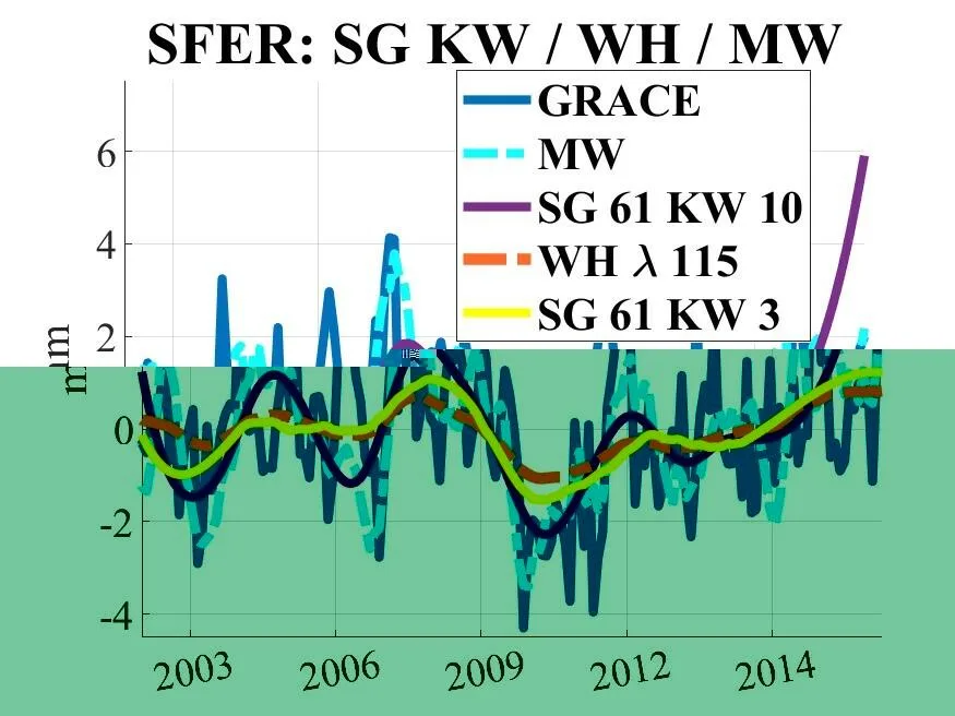
The researchers took vertical time series from 122 European GPS stations in the Nevada Geodetic Laboratory solution for 2002–2018. They subtracted model-predicted contributions from non-tidal atmospheric loading, non-tidal oceanic loading, and the response to barostatic sea-level variability, then detrended the series and resampled from daily to monthly intervals. For comparison, they used GRACE data in the form of release-06 mascons, converted to vertical displacements at station locations. The key tool was a weighted Savitzky–Golay filter with a Kaiser window: it fits a third-degree polynomial to a moving window of 61 months, corresponding to a cutoff frequency of about 1.3 years. Unlike a simple moving average, this filter preserves the shape of peaks and pseudo-periodic components, and compared with the Whittaker–Henderson filter, it yields more pronounced amplitudes in the middle of the series.
Results
After removing loading products, the average Pearson correlation between low-frequency GPS and GRACE components rose from 0.15 to 0.45. In central Europe, coefficients exceeded 0.6, while in Scandinavia, along the Atlantic coast, and near the Mediterranean Sea they dropped to zero or became negative. This behavior is explained by GRACE's coarse grid, which fails to capture local hydrospheric effects near coasts and in areas of complex topography. At station GLSV in Kyiv, GPS recorded a sharp subsidence in 2010–2011 linked to snow and ice accumulation on the Dnieper dam and subsequent water release, whereas GRACE missed this episode. At station OPMT in Paris, GPS showed slow subsidence of the Paris Basin, invisible to GRACE. Comparison with the ENSO index revealed strong anticorrelation with a 4–6 month lag across most of Europe, except in the central part.
Implications
The study shows that GPS stations can detect long-period hydrospheric changes where GRACE is blind, especially in coastal areas and on local features like river dams. This changes the view of ground-based geodesy's applicability: previously it was thought that on timescales longer than a year the GPS signal was too noisy, but now it is clear that after careful removal of loads and appropriate filtering, it becomes a reliable tool. The contrast with neighboring works in the archive, which focus on gravitational waves or space clocks, is obvious: here the subject is slow processes on Earth's surface, and the method is not detecting rare events but routine processing of multi-year series. This is the first systematic test of GPS's long-period sensitivity over Europe, where previously only seasonal signals were compared.
Future development
The topic could evolve toward automatic drought and flood monitoring using thousands of GPS stations worldwide. Since the Nevada Geodetic Laboratory solution updates almost in real time, it becomes possible to track rapid hydrospheric events without waiting for new satellite missions. Further refinement of the Savitzky–Golay filter, accounting for colored noise and adaptive window width, could isolate even subtler signals. Combining GPS with GRACE Follow-On and future gravimetric missions is also of particular interest for constructing consistent high-resolution water-storage maps.
Impact
The results will affect hydrogeodesy, climatology, and water resource management. They will give hydrologists a tool for assessing groundwater storage in densely populated areas where satellite gravimetry fails.
Next steps
The next step is to test the ENSO anticorrelation on a larger set of stations and link it to regional climate models. It is also worth investigating why the correlation with ENSO is weaker in central Europe than at the periphery.
Key open problems
For hydrogeodesy, the main unresolved problem is separating the contributions of tectonics, postglacial rebound, and local water processes in GPS vertical displacements. The study shows that at stations with tectonic activity, such as ANKR in Turkey, correlation with GRACE drops, but it does not offer a way to separate these effects. Another problem is accounting for non-tidal oceanic loading near coasts, where residual model errors can mask the hydrospheric signal.
The Savitzky–Golay filter used in this study was proposed back in 1964 for smoothing spectroscopic data, yet it remains one of the fastest and most reliable ways to extract slow trends from noisy series. In geodesy, it has been applied to seismic signals and self-potential anomalies, but for hydrospheric time series it was a novelty.
Key numbers
- GPS stations: 122
- observation period: 2002–2018
- GRACE resolution: about 300 km
- average correlation after correction: 0.45
- filter cutoff frequency: about 1.3 years