Lake Toba: Three Forces Pulling the Water Level Down
Context
This work stands apart: there is little nearby, the closest neighbor in the archive is a study on anomalous heat capacity of water, and the thematic map group combines temperature, heat capacity, quantum teleportation, and tunneling. This is not accidental: Lake Toba is a giant natural reservoir of heat and water, and its response to climate shifts matters beyond Indonesia. Neighboring studies on El Niño, Tibetan precipitation, and changing rainfall patterns show that climate instability is already reshaping water systems worldwide. This review gathers scattered evidence about one lake into a coherent picture but does not provide a definitive answer about the dominant factor.
Methods
This is a critical literature review: the authors collected and compared published data on Lake Toba's water level, precipitation, temperature, and land use from 1993 to 2020. They analyzed water level time series from 1957 to 2016, maps of precipitation anomalies during El Niño, temperature and precipitation trends from the Parapat weather station, and satellite estimates of open land area changes. Two water balance models with projections to 2057 were examined separately. Comparisons with dozens of lakes worldwide, from Victoria to Urmia, helped identify common mechanisms, but for Toba, direct modeling experiments to separate the contributions of factors are still lacking.
Results
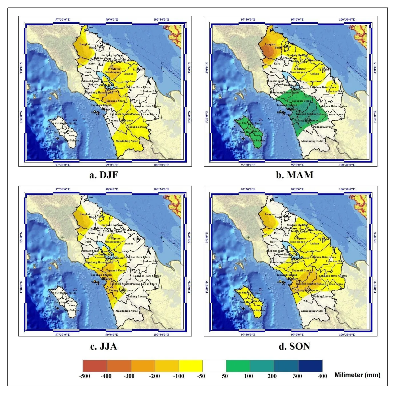
Lake Toba's water level has been falling by an average of 2.4 cm per year from 1957 to 2016, with some periods seeing declines of 2–2.5 m over several years. During strong El Niño events (1982/83, 1997/98, 2015/16), precipitation in the catchment decreased by 50–100 mm per season, and the dry season lengthened. Air temperature around the lake is rising: maximum by 0.05 °C per year, mean by 0.02 °C. Precipitation is decreasing: by 3.18 mm per year in the dry season and by 16.33 mm in the wet season. The area of open land (clearings, construction) increased from 7.54 km² in 1990–1997 to 68.10 km² in 2013–2018, and its correlation with lake area is negative (−0.77). Water balance models predict a surplus: inflow of 209.09 m³/s versus outflow of 82.37 m³/s, which would keep the level within 905.30–905.50 m. However, climate projections allow for extreme droughts, and no study has determined which of the three factors, El Niño, warming, or human activity, contributes the most.
Implications
Unlike neighboring studies on climate indices and precipitation, this review focuses on a specific lake as an integrator of all impacts. It shows that for Toba, unlike Lake Urmia where the anthropogenic contribution is estimated at 80%, no quantitative separation of factors exists. This is the first attempt to bring together hydrological, meteorological, and socio-economic data for Toba, and it reveals a major gap: the lack of a unified model that simultaneously accounts for El Niño, local warming, and water withdrawal. The work aligns with the broader 'climate–lakes' research agenda, but its value lies in framing the problem for future interdisciplinary projects.
Future development
The topic will evolve toward high-resolution coupled 'climate–hydrology–land use' models. For Toba, regional climate projections linked to a water balance model are needed to forecast water levels under different emission and water use scenarios. Attribution methods similar to those used for Lake Urmia are also promising to quantitatively separate natural variability from anthropogenic impacts.
Impact
The results are important for water resource management in North Sumatra, hydropower, and tourism. They also provide a methodological reference for studying other large tropical lakes affected by El Niño.
Next steps
Conduct comprehensive modeling of Lake Toba's water balance under climate and land use change scenarios. Establish continuous monitoring of water level, precipitation, temperature, and water withdrawal in the catchment.
Key open problems
The main unresolved problem in lake hydrology is the quantitative attribution of water level changes when climate variability, global warming, and local human activities act simultaneously. For Lake Toba, this is particularly acute due to the lake's economic importance and the lack of an integrated observational network.
Lake Toba formed about 75,000 years ago in the caldera of a supervolcano after one of the largest eruptions in Earth's history. Its average depth is 228 m, and its water is used for cooling an aluminum smelter and generating electricity.
Key numbers
- water level drop: 2.4 cm/yr (1957–2016)
- maximum single drop: 2.5 m (1984–1987)
- maximum temperature increase: 0.05 °C/yr
- open land area increase: from 7.54 to 68.10 km²
- projected water surplus: inflow 209.09 m³/s vs. outflow 82.37 m³/s