Monsoon 18 Months Out: Where the Predictability Hides
Context
Forecasting the Indian summer monsoon (June–September) is a matter of food security for hundreds of millions of people. Since 1884, when Blanford built the first empirical model, the accuracy of seasonal forecasts has barely improved: the correlation of operational forecasts by the India Meteorological Department for 1989–2012 is negative (-0.12). Related papers in our archive follow a common thread: they look for precursors in El Niño, droughts, and neural network approaches, but none has assessed the limit of predictability at such long lead times. This work stands apart: it shows for the first time that the potential for predictability persists even at an 18-month lead, and explains why linear methods fail to realize it.
Methods
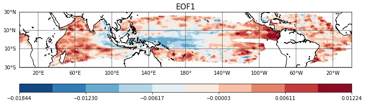
The authors abandoned the traditional approach of selecting a predictor based on a correlation map in a single region (e.g., the Nino3.4 index). Instead, they take the global field of depth anomalies of the 20-degree isotherm (D20) in the tropics (30°S–30°N) and project it onto the correlation map with monsoon rainfall over all 24 months of lag. This predictor, Dp, sums contributions from three ocean basins at once: the Pacific, Indian, and Atlantic. For comparison, the same projections are made for the heat content of the upper 200 meters (Hp) and sea surface temperature (Sp). A simple linear regression is then trained on a sliding 50-year window, and retrospective forecasts are made for 88 years (1923–2010). Error growth is assessed from the spread of D20 trajectories for 20 strong El Niño events.
Results
The correlation between the predictor Dp(-18), built from December D20 anomalies two years before the monsoon, and ISMR rainfall reaches 0.84 over the entire 1871–2008 period. In retrospective tests with partial independence, the correlation rises to 0.86 with an RMSE of 41.94 mm, close to the potential predictability limit previously estimated at 0.82. Meanwhile, a 5-month forecast yields 0.81, and a 1-month forecast only 0.66. Paradoxically, the longer the lead time, the higher the skill. The reason is that December conditions two years ahead correspond to the slow error-growth phase in the El Niño recharge-discharge cycle, whereas May conditions fall into the rapid-growth phase. Fully independent forecasts for 1980–2010, where data from that period were used neither to search for the predictor nor to train, collapse to a correlation of 0.07. This shows that the high potential rests on small-scale nonlinear D20 anomalies that vary from event to event and are not captured by a linear scheme.
Implications
This work provides the first quantitative estimate of the predictability limit for the Indian monsoon at 18 months and explains why linear empirical models have never reached it. Unlike related studies that seek individual precursors or improve short-term forecasts, here it is shown that the signal is distributed across the entire tropical belt and requires a nonlinear approach. This shifts the focus from searching for a "better index" to developing nonlinear methods capable of capturing the event-to-event variability of El Niño.
Future development
The next logical step is to apply deep learning to the same D20 field to automatically extract nonlinear patterns that linear projection misses. The success of neural networks in long-range El Niño forecasting (Ham et al., 2019) suggests that a similar approach could work for the monsoon. It is also worth checking whether the high correlation persists when using independent reanalysis data, such as ORAS5 instead of SODA.
Impact
The results directly influence the development of seasonal forecasting systems for agriculture and water resource management in India. They also provide a benchmark for dynamical models: if a model fails to reproduce the slow evolution of D20 in the tropics, its long-range monsoon forecasts are doomed.
Next steps
Build a nonlinear model (e.g., based on convolutional neural networks or gradient boosting) trained on the same D20 field, and test it in a fully independent mode over the last 30 years. In parallel, assess how the choice of ocean reanalysis affects the robustness of the predictor.
Key open problems
This work directly addresses the unresolved problem of seasonal monsoon predictability: why all operational models, both empirical and dynamical, systematically fall short of the potential predictability limit. The authors show that the root of the problem is not the absence of a signal but its nonlinear nature, which linear methods ignore. This echoes the long-standing debate about the "spring predictability barrier" of El Niño and how event-to-event variability limits forecasting.
A correlation of 0.86 at 18 months ahead is higher than most one-season forecasts. For comparison, the best dynamical systems achieve about 0.6 at 1–2 months.
The idea of peering years into the climate via slow ocean waves recalls Kim Stanley Robinson's Mars trilogy, where colonists use long-term climate cycles to plan terraforming.
Key numbers
- correlation of 18-month forecast: 0.86
- correlation of 1-month forecast: 0.66
- RMSE of 18-month forecast: 41.94 mm
- data period: 1871–2010
- number of strong El Niño events for error assessment: 20