Hurricane Season 2025: Why the Ocean Was Warm but Storms Were Few ✛
Context
Atlantic hurricane seasons are usually governed by El Niño and ocean temperature. In 2025, both factors were weak or favorable, yet activity turned out unexpectedly moderate. This work sits apart from neighboring studies: nearby in the archive are papers on Martian climate swings, solar tidal rhythms, and Enceladus's heat pump, but none touch on Earth's tropical cyclones. That makes this dissection of the 2025 season isolated, yet valuable as a test of theoretical links between waves and cyclogenesis.
Methods
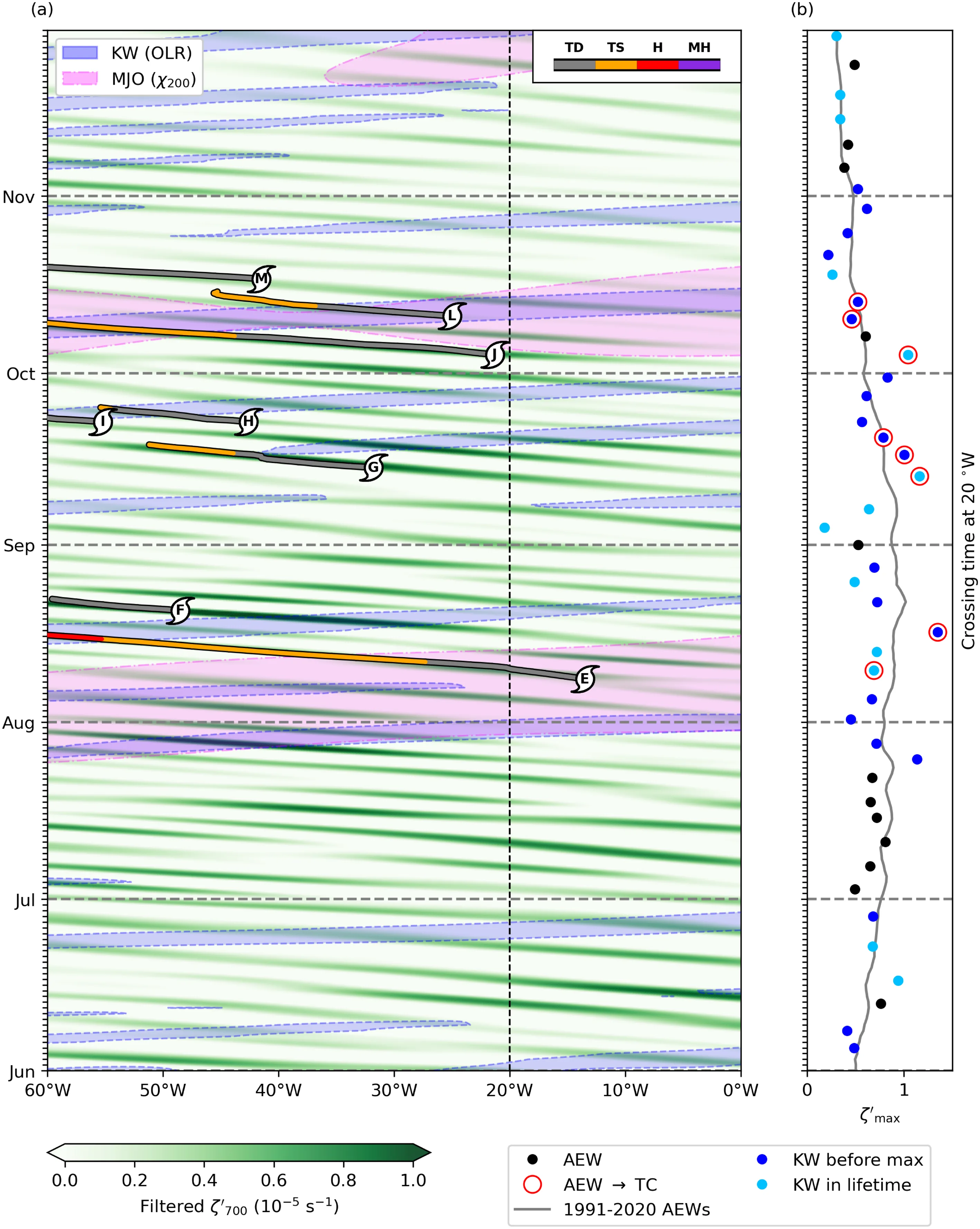
The author used ERA5 reanalysis data, OISST satellite temperatures, and HURDAT2 hurricane tracks. African easterly waves were isolated with a bandpass filter on 700-hPa relative vorticity with periods of 2–6 days. Kelvin waves were filtered from outgoing longwave radiation anomalies, and Madden–Julian oscillation phases were tracked using the RMM index. For each storm, they checked whether it came under the influence of these waves in the days before its peak intensification.
Results
The season produced 13 named storms, of which 5 were hurricanes and 4 were major hurricanes. The accumulated cyclone energy (ACE) totaled 132.5 units, close to normal, but 85% of that energy came from just four storms. The daily energy distribution had an excess kurtosis of about 13, the second highest in the modern record. Three hurricanes reached Category 5, the most since 2005. African easterly waves were as numerous as usual but weaker than average during the lulls. 74% of waves were influenced by Kelvin waves, which matches the climatology.
Implications
Unlike neighboring studies that build models or seek general patterns, this one offers a detailed dissection of a single season, focusing on a rare combination of factors. It is the first test, on real data, of the hypothesis that Kelvin waves can 'nudge' African waves toward becoming hurricanes. The work shows that when El Niño is weak and the ocean is warm, less conspicuous players become decisive: the monsoon, the upper-tropospheric cyclone, and intraseasonal waves.
Future development
The topic could develop toward forecasting the Kelvin waves and the Madden–Julian oscillation themselves, as well as their interaction with the monsoon. An open question is whether these mechanisms will become more important in a future climate with a more stable atmosphere. Another direction is the study of rapid intensification, which occurred several times in 2025 and may be becoming more frequent.
Impact
The results are useful for seasonal hurricane forecasts and for understanding how climate change is altering the character of tropical cyclones. They also matter for the insurance industry and warning services, which need to account for a growing share of powerful but rare storms.
Next steps
A natural next step is a systematic analysis of all seasons since 1991 to examine the link between Kelvin waves and the strength of African waves. It would also be useful to check how well models reproduce the lulls observed in 2025.
Key open problems
This work touches on the unresolved problem of predictability of intraseasonal variability in tropical cyclones. It remains unclear why Kelvin waves actively influence cyclogenesis in some years but not others, and how that relates to the monsoon and the upper-tropospheric cyclone.
The knowledge machine's view
This section is addressed to the author of the paper and their colleagues. Neighbouring works were found by meaning-based search across our archive, not by word overlap. We do not review: we show the field around the work.
What the work does
The author analyzed the 2025 Atlantic hurricane season using ERA5, OISST, and HURDAT2 data. He isolated African easterly waves with a vorticity bandpass filter, Kelvin waves from OLR anomalies, MJO phases from the RMM index, and for each storm tracked the influence of waves before intensification. The season produced 13 storms, 5 hurricanes, 4 major hurricanes, an ACE of 132.5, with an excess of daily energy of about 13 and three Category 5 hurricanes; 74% of the waves experienced the influence of Kelvin waves.
Where its strength is
A detailed analysis of a single season with a rare combination of factors, for the first time testing on real data the hypothesis about the role of Kelvin waves in the intensification of African easterly waves. It shows that under weak El Niño and a warm ocean, the monsoon, an upper-tropospheric cyclone, and intraseasonal waves become decisive.
Where it could go next
- It might be interesting to see how intraseasonal waves interact with slower climate modes, similar to how the analysis of Martian climate swings considers long-period oscillations. This would help place the 2025 season in a broader context of variability.based on: The Climate Swings of Ancient Mars arXiv:2601.07159v2
- Nearby work on the Sun's tidal rhythms analyzes periodic influences on a system. It would be curious to check whether MJO phases or Kelvin waves are modulated by any external rhythms, which could explain the rare combination of factors in 2025.based on: The Sun's Tidal Rhythms arXiv:2602.11227
- The archive includes a study of the ocean conveyor belt on the brink, which examines the sensitivity of large-scale circulation to perturbations. One could compare how upper-tropospheric cyclone anomalies in 2025 relate to changes in ocean circulation and assess how likely such coincidences are in the future.based on: The Ocean Conveyor on the Brink arXiv:2606.08623
Worth trying
- Test how often configurations similar to 2025 occur in historical data, using clustering of MJO phases, Kelvin waves, and monsoon indices.
- Assess whether including an upper-tropospheric cyclone index adds predictive skill to seasonal hurricane forecasts.
- Compare the sensitivity of African easterly waves to Kelvin waves across different MJO phases using composite analysis.
Why this may matter
Such single-season analyses help calibrate expectations from climate models and identify key processes that may become more important under climate change.
Nearby works in our archive
- The Sun's Tidal Rhythmssimilarity 0.47
- The Climate Swings of Ancient Marssimilarity 0.46
- The Ocean Conveyor on the Brinksimilarity 0.46
- Roiling Lava Ocean Doesn't Shift the Hot Spotsimilarity 0.46
- Space Weather by the Seasonssimilarity 0.45
The archive is sparse around this work: the closest review is only 0.47, against a usual 0.64. It looks like few have drilled nearby.
In Hurricane Melissa, a dropsonde recorded a wind gust of 252 miles per hour (405 km/h), a new world record for a gust measured inside a tropical cyclone.
Key numbers
- Total cyclone energy (ACE): 132.5 units
- Share of energy from four storms: 85%
- Excess kurtosis of daily energy distribution: about 13
- Number of days with favorable MJO phase: 25 (second lowest since 1991)
- Sea surface temperature anomaly in MDR: +0.47°C