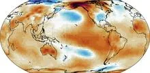
The Niño 3.4 region is a specific rectangle of the equatorial Pacific Ocean, stretching from 5°S to 5°N latitude and 170°W to 120°W longitude. It sits in the central Pacific, roughly halfway between the coast of South America and the international date line. Scientists track the average sea-surface temperature in this box because it serves as the primary indicator for El Niño and La Niña events, the periodic warming and cooling of the tropical Pacific that disrupt weather patterns worldwide.
History
The index was formalized by the U.S. Climate Prediction Center in the 1990s as a standard for operational El Niño monitoring, building on earlier regional indices like Niño 1, 2, and 3.
How it works
The region's temperature anomaly—the difference from its long-term average—is computed from satellite and buoy data. When the anomaly stays above +0.5°C for several months, an El Niño is declared; below -0.5°C signals La Niña. This particular box is chosen because its temperature swings correlate strongly with atmospheric circulation changes, making it a sensitive gauge of the ocean-atmosphere coupling that drives these climate phenomena.
In practice
It is the benchmark used by meteorological agencies worldwide to declare El Niño or La Niña conditions and to issue seasonal climate forecasts for agriculture, water management, and disaster preparedness.
Fun fact
A single degree Celsius anomaly in this region can shift rainfall patterns across half the globe, from droughts in Australia to floods in California.
In 1991, Mount Pinatubo erupted with such force that it blanketed the planet in a thin veil of ash and gases for years. That veil, like a blanket on a hot night, trapped heat and cooled the ocean surface, causing tropical sea surface temperatures to dip. This event marks the start of a detective story about why some oceans are spawning ever more ferocious hurricanes while others remain calm.
A tuning fork produces a pure tone, but if you strike it too hard, it starts to rattle, and a musician might mistake that rattle for complexity in the sound.
The Sun is a giant nuclear reactor that continuously sends us light and heat. But it also has another, almost silent postal service: every second, tens of billions of neutrinos, ghostly particles born in the thermonuclear furnace, fly through a square centimeter of your palm. Most of them leave no trace.
Imagine a radiator in a room: it heats up, but if its surface is clogged with dust, heat escapes less efficiently. Something similar is happening to our planet. Earth receives energy from the Sun and must radiate the excess back into space, otherwise temperatures rise. Scientists call this ability to shed excess heat radiative feedback.
Beneath a thin layer of red dust on Mars lies water ice. Its presence was confirmed by the Phoenix lander and orbital instruments, but the mystery remained: why is the ice always just a few centimeters below the surface?
The answer lies in the wobbles of Mars' axial tilt.
The orchestra assembled, the instruments were tuned, but there was barely any music: that's what the 2025 Atlantic hurricane season looked like. The ocean was the fifth warmest on record, and a weak La Niña usually adds strength to storms. But instead of a continuous concert, we got isolated thunderous chords: three Category 5 hurricanes, with silence in between.
Why was the orchestra silent?
In May 2024, thermometers in Jalisco seemed to go haywire: on May 10, one station recorded 38.4°C, nearly matching the historical maximum from 1994. The heat was so intense that even agave plants, accustomed to scorching conditions, slowed their growth. And the rains, which usually arrive in June, were delayed, leaving farmers nervously glancing at the sky.
The carbon cycle is like the planet's breathing. Forests and oceans inhale carbon dioxide, while industry and wildfires exhale it back. In 2023, that inhale became gasping and shallow. At the Mauna Loa station, instruments recorded that CO₂ concentrations rose by 3.37 parts per million over the year, 86% faster than the year before.
In the summer of 2023, thermometers around the world registered numbers that even the boldest forecasts had not anticipated. The planet's average temperature rose to 1.48°C above pre-industrial levels, a jump of 0.17°C that broke the previous record as if the climate had suddenly shifted gears.
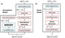
A translator at an important negotiation starts by simply repeating words, but gradually begins to anticipate what the counterpart will say. The new weather model works similarly: physics provides the framework, and machine learning learns from errors and fills in the gaps.
Seventy-five years of weather observations in India, when plotted on a graph, resemble the cardiogram of a vast organism. Instead of a single steady pulse, there are fifteen different lines, each with its own rhythm. Somewhere the heartbeat is as steady as a sleeping person's, while elsewhere it falters, as if after a quick run.
The Pacific Ocean spans half the planet, and its mood decides whether India gets rain or Australia gets drought. In the center of this giant, in a region that climatologists call NINO3.4, water temperatures rise and fall, affecting millions of lives.
The thermometer at a weather station in Delhi doesn't know it's part of a giant ear. Every day it records the temperature, and after forty years of such records, you can hear the breathing of an entire subcontinent. The India Meteorological Department divided the country's land into one-degree squares and took readings from 1970 to 2009.
Every clear night, a telescope in the Chilean desert records light from distant stars, and in those recordings, like old ship logs, traces of weather remain. The thin dark bands in the spectrum are imprints of water vapor that hung over the observatory at the moment of observation.
Every spring in Alaska, residents of the town of Nenana gather by the frozen Tanana River. They've bought lottery tickets, each marked with the day and minute they think the ice will break up. On the ice sits a tripod, connected by a rope to a clock on the shore. When the ice goes out, the tripod falls and stops the clock. That moment is the winner.