Ocean Dictates Sahel Rains ✛
Context
This work stands apart: its nearest neighbors study ocean heat pumps, space weather, and El Niño, but none have separated Sahel rains by intensity. Previously, it was thought that all rainfall variability obeyed the same oceanic teleconnections. The authors show that moderate and extreme downpours are controlled by different 'remote controls': the Atlantic and Mediterranean versus the Pacific. This shifts the perspective on rainfall prediction in a vulnerable region where harvests and lives depend on rain.
Methods
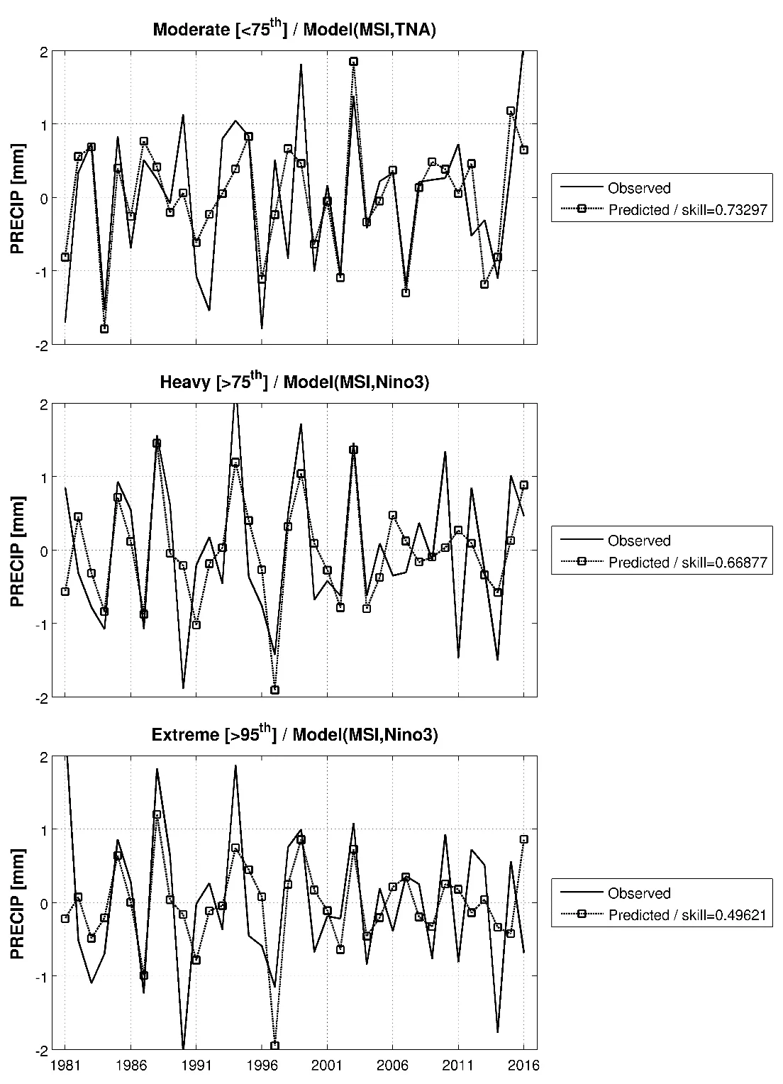
For 36 years (1981–2016), daily CHIRPS rainfall at 0.25° resolution was collected over the Sahel (20°W–10°E, 10°N–20°N). Each day with rain above 1 mm was assigned to one of four categories by percentile: weak (<50th), moderate (<75th), heavy (>75th), and extreme (>95th). For each category, values were averaged over the region, and interannual variability was isolated using a Lanczos filter (periods 1–8 years). Regressions were then calculated between rainfall indices and sea surface temperature anomalies (HadISST), as well as moisture and instability fields from ERA-Interim reanalysis. For forecast verification, stepwise multiple regression with leave-one-year-out cross-validation was applied.
Results
Moderate and heavy rains show almost no correlation with each other (0.24, not significant), while heavy rains correlate almost perfectly with total rainfall (0.97). This means that interannual variability of Sahel rains is driven by heavy and extreme events, even though moderate and heavy rains contribute nearly equally to the total (49% vs. 51%). Warm waters in the tropical North Atlantic (TNA) enhance moderate rains by supplying oceanic moisture without increasing convection. La Niña in the Pacific, together with a warm Mediterranean, boosts vertical atmospheric instability and moisture content, generating heavy and extreme downpours. Analysis of moist static energy showed that moderate rains are fueled by surface evaporation, while extreme rains are driven by upper-tropospheric cooling and deep convection. The number of African easterly waves during heavy rains is twice that during moderate rains (22% vs. 11%).
Implications
Unlike neighboring studies that treat rainfall as a single stream, this work splits it by intensity and finds different 'oceanic keys.' It is the first to test that moderate and extreme Sahel rains are predictable from sea surface temperatures with different lead times. Seasonal forecasting is no longer a black box: now we can see which ocean and how many months ahead warns of each rain type.
Future development
The next step is to test how stable these relationships are over time. The 36-year period is short, and teleconnections may have shifted: El Niño has influenced the Sahel more strongly in some decades and weakly in others. Regional climate models (e.g., CORDEX-Africa) can help account for nonlinearities and clarify how the rainfall response to the ocean depends on the background state. It is also important to understand whether these patterns will persist under global warming, given that extreme storms in the Sahel have already become three times more frequent than 35 years ago.
Impact
Agriculture, water resource management, and humanitarian planning in Sahel countries will benefit from more accurate seasonal forecasts. Insurance and food security programs can prepare in advance for droughts or floods by distinguishing moderate from extreme rainfall.
Next steps
Repeat the analysis on longer rainfall records and test the robustness of ocean links. Compare results with outputs from CORDEX-Africa regional models to assess the influence of nonlinearities.
Key open problems
An open question in rainfall climatology is why the same ocean temperature anomalies affect rains differently across decades. This work suggests the answer may lie in separating rainfall by intensity, but it does not resolve the non-stationarity of teleconnections. It also remains unclear how mesoscale convective systems link large-scale oceanic signals to local extreme downpours.
The knowledge machine's view
This section is addressed to the author of the paper and their colleagues. Neighbouring works were found by meaning-based search across our archive, not by word overlap. We do not review: we show the field around the work.
What the work does
The study splits Sahel rainfall into four intensity categories and shows that moderate rains are linked to a warm North Atlantic and increased humidity, while heavy and extreme rains are tied to La Niña, a warm Mediterranean, and enhanced convection. The 36-year analysis using CHIRPS, HadISST, and ERA-Interim reveals different oceanic predictors for different rain types, and seasonal forecasts based on sea surface temperature are skillful for 2–4 months ahead.
Where its strength is
The main strength lies in splitting rainfall by intensity, which reveals distinct mechanisms driving moderate versus extreme rains and paves the way for more differentiated forecasting.
Where it could go next
- It might be interesting to see how the intensity-based split of rainfall relates to different El Niño types: there is an analysis in the archive showing that the pattern of ocean warmth alters the geography of droughts and floods.based on: Two Faces of El Niño: How Different Patterns of Ocean Heat Rewrite the Map of Droughts and Floods arXiv:1702.00218
- Nearby there is a study on El Niño phases and rainfall extremes: one could check how individual ENSO phases affect heavy and extreme downpours in the Sahel, rather than just the overall index.based on: Breathing of Tropical Rains: How El Niño Phases Drive Precipitation Extremes arXiv:1604.04050
- Another direction is to compare the predictability of moderate versus extreme rains while accounting for the uncertainty highlighted in the analysis of warm Pacific water's effect on weather unpredictability.based on: Relay of Chaos: How Warm Pacific Waters Make Weather Unpredictable arXiv:1801.00891
Worth trying
- Test whether the separation of mechanisms holds when using other rainfall datasets, such as station-based or higher-resolution satellite products.
- Try incorporating indices of different El Niño types (eastern and central Pacific) into the regression model to predict extreme rains.
- Assess how predictability from ocean temperature changes when moving from filtered indices to raw monthly anomalies.
Why this may matter
If different rain types are governed by different oceanic signals, this could improve seasonal forecasts for the Sahel and aid early warning of floods and droughts in a vulnerable region.
Nearby works in our archive
- The Overzealous Translator: Why Models Overestimate the El Niño–Hurricane Linksimilarity 0.58
- Two Faces of El Niño: How Different Patterns of Ocean Heat Rewrite the Map of Droughts and Floodssimilarity 0.55
- Relay of Chaos: How Warm Pacific Waters Make Weather Unpredictablesimilarity 0.55
- Breathing of Tropical Rains: How El Niño Phases Drive Precipitation Extremessimilarity 0.54
The archive is sparse around this work: the closest review is only 0.58, against a usual 0.64. It looks like few have drilled nearby.
Extreme storms in the Sahel now occur three times more often than 35 years ago, even though total annual rainfall has barely changed. This means rain has become less frequent but much more intense.
Key numbers
- correlation of heavy rains with total rainfall: 0.97
- contribution of heavy rains to annual total: 51%
- forecast lead time for extreme rains: 4 months
- increase in frequency of extreme storms over 35 years: 3 times
- share of African easterly waves during heavy rains: 22%