Ocean and Atmosphere Learn to Speak the Same Language ✛
Context
Forecasting a season ahead has always hinged on the ocean. The atmosphere forgets its initial state within a couple of weeks, while the upper ocean retains memory for months and slowly releases it through sea surface temperature. That is why El Niño, that warm patch in the equatorial Pacific, is the main source of predictability on timescales from a month to a year. Physical models have been learning to couple ocean and atmosphere for half a century, yet they still suffer from systematic errors such as a cold tongue in the tropics. Alongside this work, there have been attempts to predict El Niño from data and to build hybrid models, but no one before Ola had included subsurface ocean temperature in the trainable loop.
Methods
Ola consists of two neural networks trained separately and then coupled into a loop. The atmospheric component, with a 24-hour time step, was trained on ERA5 reanalysis from 1980 to 2016; the oceanic component, with a 48-hour step, on UFS-replay data from 1994 to 2016. The ocean network receives surface wind, temperature, and pressure from the atmosphere, while the atmospheric network receives sea surface temperature. Inside the ocean network, eight depth levels span from half a meter down to 300 meters, allowing the model to see the thermocline, that layer of sharp temperature change where the memory of future El Niño events resides. For ensemble forecasts, the method of lagged ensembles was used: the model was launched every six hours during the first three days of the month, yielding 12 trajectories.
Results
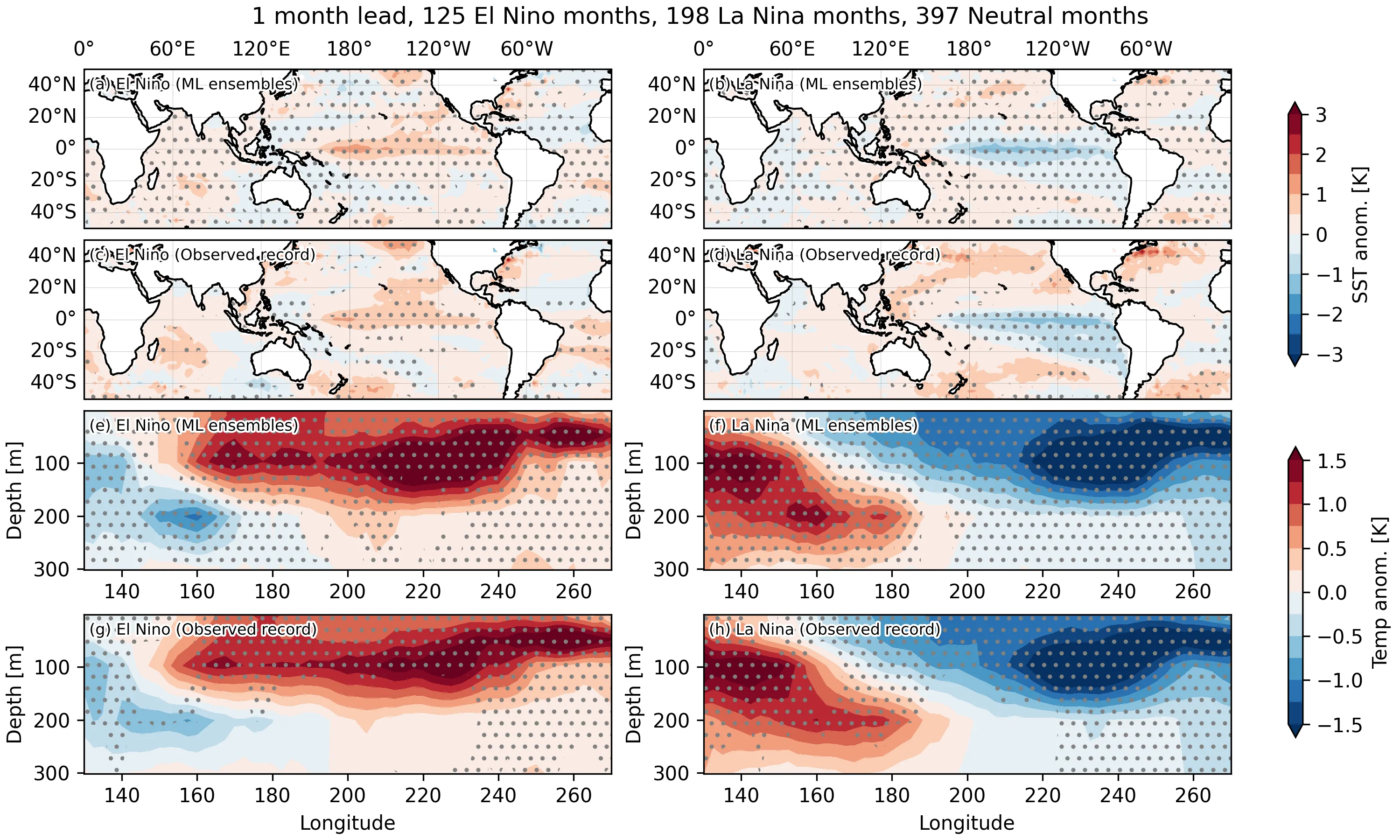
Over a five-year validation period from 2017 to 2022, Ola reproduced both El Niño and La Niña, with the amplitude of temperature oscillations in the Niño 3.4 region close to observations and the cold bias typical of GFDL-SPEAR almost absent. Along the equator, the model generated Kelvin waves propagating eastward at about two meters per second and Rossby waves drifting westward at five to ten degrees from the equator. Subsurface temperature anomalies during El Niño shifted eastward at a depth of 50 meters, just as in the real ocean. The only notable miss occurred in the winter of 2021–2022, when the model failed to sustain a third consecutive La Niña, but most operational systems also struggled with that.
Implications
Ola has shown that machine learning can bypass the curse of parameterizations, which has caused physical models to accumulate errors in the tropics for decades. The difference from neighboring works is fundamental: those either predicted El Niño from statistical indices or used only sea surface temperature, whereas Ola is the first to include the vertical structure of the upper 300 meters in the trainable loop. This is not just another emulator but a test of the hypothesis that a neural network can learn the coupled dynamics of the ocean and atmosphere, including the waves that carry heat and determine the phase of El Niño.
Future development
Currently, the model remains stable for only six months; beyond that, drifts accumulate at high latitudes. Expanding the training dataset, adding ocean currents and deeper levels, could extend the forecast to a year or more. Hybrid schemes, where a neural network is trained on millennial climate model simulations and then fine-tuned on short observational records, appear to be the most realistic path toward seasonal and interannual forecasts.
Impact
Seasonal forecasting for agriculture, energy, and water resource management will gain a tool that computes an ensemble in a minute on a single GPU instead of hours on a supercomputer.
Next steps
Systematically compare different coupled model architectures on common datasets to understand which empirical choices affect long-term stability, and train a version with a more complete ocean state vector.
Key open problems
For climate modeling, an open question remains how to avoid drift in the mean tropical temperature when moving to coupled models. Ola offers a first hint that abandoning parameterizations of convection and the boundary layer may resolve the double intertropical convergence zone problem that has plagued physical models since the 1980s.
The knowledge machine's view
This section is addressed to the author of the paper and their colleagues. Neighbouring works were found by meaning-based search across our archive, not by word overlap. We do not review: we show the field around the work.
What the work does
The paper introduces the Ola model based on the Spherical Fourier Neural Operator architecture, consisting of atmospheric and oceanic neural networks trained on ERA5 and UFS-replay. The model reproduces El Niño and La Niña, including the subsurface temperature structure, Kelvin and Rossby waves, and shows less cold bias compared to GFDL-SPEAR. For seasonal forecasts, the lagged ensemble method is used.
Where its strength is
Including the vertical structure of the upper 300 meters of the ocean in the training loop allows the model to capture thermocline dynamics, which is critical for predicting El Niño. This sets Ola apart from previous approaches that used only sea surface temperature or statistical indices.
Where it could go next
- One could consider applying the Ola approach to forecasting droughts months ahead, leveraging its ability to reproduce slow oceanic processes.based on: How a neural network, reading weather backwards, warns of drought months in advance arXiv:2607.00331
- It would be interesting to compare Ola with models that predict El Niño a year and a half in advance, to assess the limits of predictability when using the ocean's vertical structure.based on: El Niño Can Be Predicted a Year and a Half in Advance arXiv:2601.12251
- Methods from the paper on weather forecasting with a single GPU might help speed up Ola's training or inference, which is useful for operational ensemble forecasting.based on: Weather forecast on a single GPU arXiv:2603.21284
Worth trying
- Test whether including subsurface temperature data improves forecasts of extreme precipitation in the tropics.
- Use Ola to initialize high-resolution regional models to improve local forecasts.
- Evaluate how well the model reproduces teleconnections, for example, the influence of El Niño on mid-latitude weather.
Why this may matter
If machine learning models can reliably reproduce the coupled ocean-atmosphere dynamics, this could pave the way for fast and inexpensive ensemble forecasts on seasonal timescales, which is particularly important for regions dependent on climate variability.
Nearby works in our archive
- El Niño Can Be Predicted a Year and a Half in Advancesimilarity 0.54
- Weather forecast on a single GPUsimilarity 0.52
- Solar Cycles: How Magnetic Swings Sway the Futuresimilarity 0.50
- How Stratospheric Weather Alters Particle Counters Deep Undergroundsimilarity 0.49
- How the Brain Learns to Predict Without Cuessimilarity 0.49
- How a neural network, reading weather backwards, warns of drought months in advancesimilarity 0.48
The archive is sparse around this work: the closest review is only 0.54, against a usual 0.64. It looks like few have drilled nearby.
Ola produces a six-month forecast in less than a minute on a single A100 GPU, while the classical GFDL-SPEAR model needs hours on a cluster for the same calculation.
Key numbers
- resolution: 0.25° in latitude and longitude
- ocean depth: up to 300 meters, 8 levels
- forecast speed: 6 months in less than 1 minute on A100
- atmosphere training period: 1980–2016 (ERA5)
- ocean training period: 1994–2016 (UFS-replay)