Heat and Rain in Jalisco: How 2024 Broke Records ✛
Context
This work stands apart: nearby studies focus on El Niño prediction, precipitation regime changes, and space weather, but there are almost no direct neighbors in Jalisco's regional climatology. This underscores the importance of local analysis: global models provide a broad picture, but the vulnerability of a specific region depends on local orography and atmospheric circulation. Jalisco, where agriculture depends on seasonal rains and the famous tequila is made from blue agave, is particularly sensitive to shifts in precipitation and temperature.
Methods
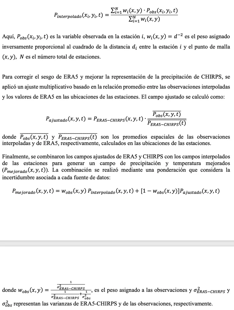
The authors combined three data sources: CHIRPS satellite precipitation estimates at 0.25° resolution, ERA5 reanalysis for temperature and atmospheric fields, and observations from 13 weather stations distributed across the state. To obtain continuous fields, they used inverse distance weighting interpolation. They then applied multiplicative bias correction to ERA5 and CHIRPS against station data. The final precipitation and temperature fields were derived by weighted merging of the three sources, accounting for their variances. Anomalies were calculated relative to the 1991–2020 climatology. For atmospheric circulation analysis, they computed anomalies of geopotential height at 500 hPa and specific humidity at 850 hPa for May–June.
Results
The 2024 rainy season started later than usual: in most regions, sustained rainfall only set in after July 20. It also ended earlier, with a sharp decline from mid-September. As a result, positive precipitation anomalies (up to 150–200 mm) were observed in the center and south of the state, while the coastal strip and the borders with Colima and Michoacán received 80–200 mm less than normal. The temperature anomaly from May to October reached 2.3°C, breaking the 2023 record of 2.1°C. May 2024 was the warmest May since at least 1970, with deviations reaching 4°C in the east and in Los Altos. On May 10, the Instituto station recorded 38.4°C, nearly matching the historical maximum of 38.6°C from 1994. Field analysis showed that in May–June, an anticyclone dominated over Mexico, suppressing convection and enhancing surface warming.
Implications
This work differs from its archive neighbors by providing a detailed regional picture based on the fusion of three data types, rather than global or continental estimates. It shows that even under neutral ENSO conditions during the main rainy season, local atmospheric conditions can lead to extreme anomalies. This is the first quantitative assessment for Jalisco of the record 2023 warming, tied to specific agricultural impacts.
Future development
The topic could evolve toward operational monitoring and forecasting: the state currently has only one Doppler radar and a limited station network. Expanding observations would allow better tracking of local storms and droughts. Also promising is studying the link between ENSO phases and regional anomalies, considering nonlinear interactions, for example with the Madden–Julian Oscillation.
Impact
The results directly affect Jalisco's agriculture, especially corn and blue agave cultivation, as well as water resource management and urban infrastructure under extreme rainfall events.
Next steps
Next steps include expanding the weather station network, installing additional radars, and implementing high-resolution seasonal forecasts for agricultural planning.
Key open problems
This work highlights a key problem in regional climatology: how to move from global models to local forecasts that account for orography and mesoscale processes. Also open is the question of the contribution of anthropogenic warming versus natural variability to record temperatures, which requires attribution studies.
The knowledge machine's view
This section is addressed to the author of the paper and their colleagues. Neighbouring works were found by meaning-based search across our archive, not by word overlap. We do not review: we show the field around the work.
What the work does
The authors analyzed the climate anomalies of 2024 in Jalisco by combining ERA5 reanalysis data, CHIRPS satellite precipitation estimates, and observations from 13 weather stations. They identified a late onset and early end of the rainy season, significant positive precipitation anomalies in the center and south of the state, and a deficit on the coast, as well as a record temperature anomaly of 2.3°C for May–October. An analysis of atmospheric circulation revealed the dominance of an anticyclone over Mexico in May–June, which suppressed convection.
Where its strength is
The strength of the work lies in its detailed regional analysis, based on the fusion of three independent data sources, which allowed for quantitative estimates of anomalies with high spatial resolution. This provides a concrete picture of Jalisco's vulnerability, including impacts on agriculture, and underscores the importance of local atmospheric conditions even during a neutral ENSO phase.
Where it could go next
- It might be interesting to compare the identified anticyclonic regime over Mexico with the mechanisms described in the study on the influence of the Pacific Ocean on heatwaves over Eurasia, to check whether similar teleconnections also operate for North America.based on: The Pacific Ocean Conducts the Heat Over Eurasia arXiv:2404.00453
- A related avenue is the analysis of how El Niño phases drive extreme precipitation in the tropics; one could examine how the shift in the rainy season in Jalisco relates to typical patterns for different ENSO phases, including neutral conditions.based on: Breathing of Tropical Rains: How El Niño Phases Drive Precipitation Extremes arXiv:1604.04050
- Given that 2024 followed the strong El Niño of 2023, it may be worthwhile to study how the anomalies in Jalisco fit into the global picture of post-El Niño warming, as described in the study on the record heat of 2023.based on: Earth Took Off Its Sunglasses: Why 2023 Was Anomalously Hot arXiv:2405.19986
Worth trying
- Test whether the identified anticyclonic regime persists in other years with a late onset of the rainy season in Jalisco, using the reanalysis archive.
- Compare precipitation anomalies in Jalisco with ENSO indices and other climate modes to identify potential predictors for seasonal forecasting.
- Assess how well global climate models reproduce the regional anomalies of 2024 to understand their suitability for local scenarios.
Why this may matter
Detailed regional analysis is crucial for understanding how global climate signals, such as El Niño and anthropogenic warming, manifest in specific vulnerable regions. For Jalisco, where agriculture depends on seasonal rains, such studies can serve as a basis for adaptation measures and improved seasonal forecasts.
Nearby works in our archive
- The Pacific Ocean Conducts the Heat Over Eurasiasimilarity 0.62
- Breathing of Tropical Rains: How El Niño Phases Drive Precipitation Extremessimilarity 0.57
- El Niño 2023: a year-long warningsimilarity 0.57
- Earth Took Off Its Sunglasses: Why 2023 Was Anomalously Hotsimilarity 0.56
The closest work in the archive sits at 0.62 by meaning — the usual level for our corpus.
Blue agave, used to make tequila, employs a special type of photosynthesis (CAM) that allows it to conserve water. But even such hardy plants suffer from heat: warm nights hinder sugar accumulation, reducing the quality of the raw material.
Key numbers
- temperature anomaly (May–October 2024): 2.3°C
- previous record (2023): 2.1°C
- maximum temperature on May 10, 2024: 38.4°C
- historical maximum in 1994: 38.6°C
- precipitation deficit on the coast: 80–200 mm