OISST v2.1 is a dataset of daily sea-surface temperatures produced by NOAA, covering the global ocean from September 1981 to the present. It blends measurements from satellites, ships, and buoys to create a complete map on a regular grid with a resolution of 0.25 degrees (about 25 kilometers). The 'v2.1' denotes the second major version with a subsequent update, improving accuracy and consistency over earlier releases.
History
The dataset was developed by NOAA's National Centers for Environmental Information, building on earlier versions from the 1980s; v2.1 was released in 2020 as an improved update.
How it works
Satellite infrared and microwave sensors measure the temperature of the ocean's skin layer, while in-situ instruments (buoys and ships) provide ground-truth readings at depth. The dataset uses an optimal interpolation scheme to combine these disparate observations, filling gaps in cloud-covered or remote regions and producing a seamless daily field. The result is a long, consistent record that scientists use to track ocean warming, El Niño events, and marine heatwaves.
In practice
It is widely used in climate research, weather forecasting, and fisheries management to monitor ocean conditions and validate climate models.
Fun fact
The 'skin' temperature measured by satellites can be a few tenths of a degree cooler than the water just below, a subtle difference that matters for precise climate tracking.
A star blinks every 38 seconds. This is no random twinkle: inside the white dwarf WD 0158−160, steady oscillations run like the beats of an invisible metronome. From the rhythm of those beats and the star's precise distance, astronomers have computed its mass and temperature — without ever looking at its spectrum.
On Mars, as on Earth, the air breathes: pressure rises and falls in rhythm with the daily tide — a wave heated by the Sun. But hidden in the InSight recordings was another, weaker wave. It's like an echo that gets lost in the loud sound of the main tone.
This weak wave is called a Kelvin wave. It circles the planet like ripples on water from a thrown stone.
From 1987 to 1991, astronomers last measured how Jupiter's icy moons reflect radio waves. Then came a long pause. In 2011–2024, researchers aimed a radar beam at Europa again: this time using the 70-meter antenna at Goldstone and the Green Bank Telescope.
Ice is nearly transparent to radio waves, like clear window glass is to light.
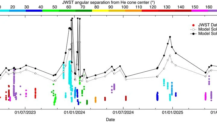
Every morning, a janitor sweeps leaves into a pile. The Sun, as it travels through the galaxy, does something similar: its gravity gathers diffuse interstellar gas into an invisible cone — a giant funnel.
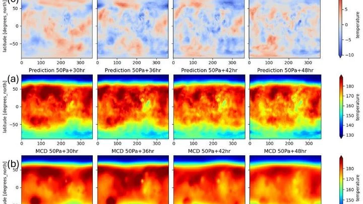
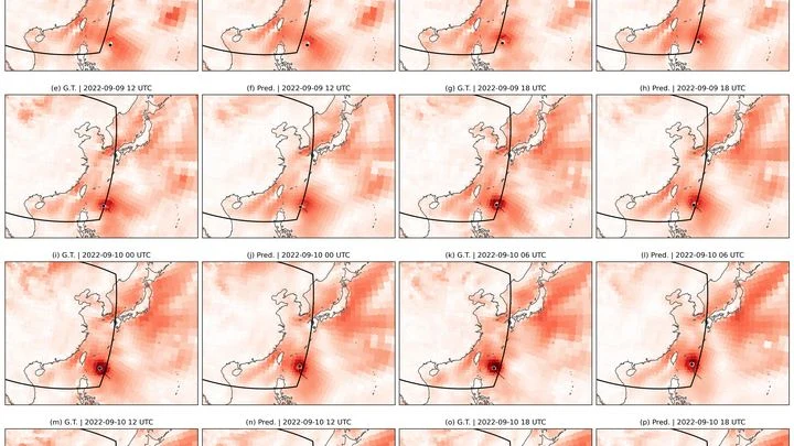
Meteorologists have grown used to trusting neural networks: the GraphCast model predicts Earth's weather days ahead by drawing on global snapshots of the atmosphere. But this 'brain' can be transplanted to another planet — where the air is thin and the Sun warms differently.
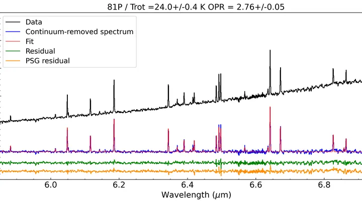
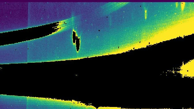
In March 2023, the James Webb Space Telescope pointed its instruments at the short-period comet 81P/Wild 2. This celestial body, about the size of a small town (nucleus radius around 1.77 km), is already familiar to scientists: in 2006, the Stardust probe flew through its tail and collected dust samples that were later studied in Earth laboratories.
A living power system is like an organism: power lines are vessels, current is blood. Data, however, are nerve impulses that used to be lost. mAIEnergy connects these 'nerves' to a shared 'brain'. This data repository combines satellite images, electricity meter readings, articles, and weather reports.
For decades, global atmospheric models resembled artists forced to paint planetary storms with coarse brushstrokes: a resolution of 25–100 km forced them to 'guess' convection through approximate schemes, introducing systematic errors in rainfall and climate forecasts.
In 1991, Mount Pinatubo erupted with such force that it blanketed the planet in a thin veil of ash and gases for years. That veil, like a blanket on a hot night, trapped heat and cooled the ocean surface, causing tropical sea surface temperatures to dip. This event marks the start of a detective story about why some oceans are spawning ever more ferocious hurricanes while others remain calm.
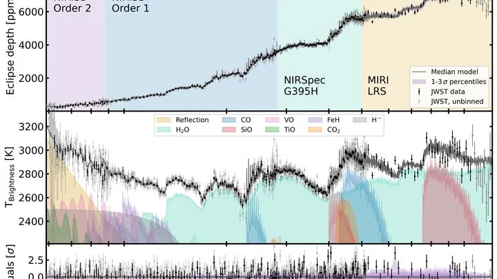
WASP-121 b is not just a hot ball. It's a world where iron vaporizes and the sky glows with its own heat. A fresh look at it has revealed what 'ingredients' went into making it.
The James Webb Space Telescope has for the first time clearly detected vaporized silicon monoxide in its atmosphere — a refractory substance usually locked inside dust grains.
A tuning fork produces a pure tone, but if you strike it too hard, it starts to rattle, and a musician might mistake that rattle for complexity in the sound.
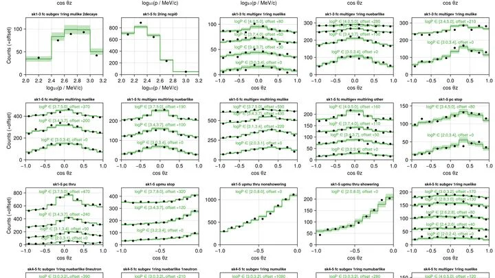
Neutrinos are often compared to a radio broadcast picked up by different receivers. One station sends a signal, but antennas in Japan, Antarctica, and at the bottom of the Mediterranean Sea hear it differently — due to distance, interference, and antenna orientation.
Astronomers aimed JWST at the rocky exoplanet LHS 3844 b — a world orbiting another star, where a year lasts just 11 hours. The planet is tidally locked: one side always faces the star, with a permanent scorch of 770°C, while the night side is plunged into icy darkness.
A giant planet hangs in space in complete solitude, separated from its star by a distance 160 times greater than the path from the Sun to Pluto. The light from its parent star arrives so faintly that the surface temperature barely exceeds 200 degrees Celsius — about as warm as a well-heated sauna.
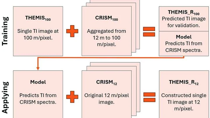
Warm rock and cold sand cool at different rates at night. An instrument orbiting Mars measures this heat, revealing whether the surface is loose dust, a dense crust, or solid rock. But thermal images have a resolution of 100 meters per point: an entire football stadium fits into a single pixel. Fine details (the beds of ancient streams, the edges of lava flows) are simply invisible.
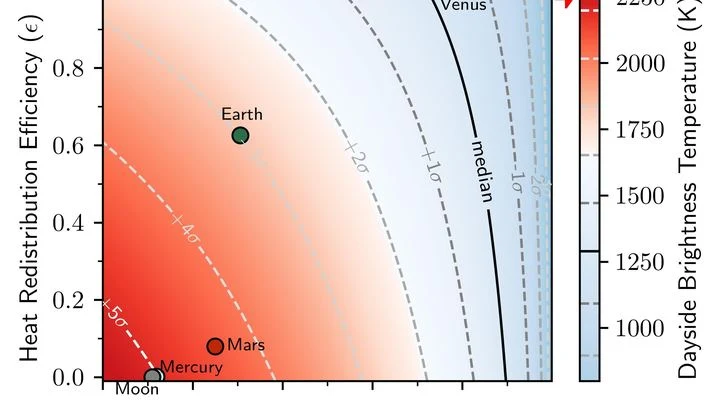
A hot skillet on the stove glows in the dark, but if you cover it with a lid, the heat escapes more slowly and the surface doesn't look as bright. That's roughly the situation on planet HD 3167 b: it always shows the same face to its star, and the dayside is heated to temperatures that melt rock.
The Sun pulses in a slow rhythm, and that rhythm can be heard in the rains over Brazil. Sunspots on the solar disk thicken and thin roughly every eleven years, and along with them, pressure in the Pacific Ocean shifts, sea surface temperatures change, and then rainfall amounts in the northeast of the country follow suit.
When an exoplanet briefly eclipses its star, starlight passes through its air and absorbs its chemical taste. This technique, the transit method, is the core of how the James Webb telescope works.
The atmosphere is a chaotic system, and a detailed global forecast requires monstrous computing power. StretchCast sidesteps this by working like the human eye: it creates 'sharp vision' over a selected region with an ultra-fine grid, while seeing the rest of the world blurry, but sharp enough to capture global connections.
Astronomers have tested the new Vera C. Rubin telescope in Chile, much like adjusting the focus and aperture on a brand-new camera. The first images covered a patch of sky the size of 60 full Moons, and immediately revealed millions of galaxies and stars. The imaging was done in various colors, from invisible ultraviolet to thermal infrared.
Light from a distant galaxy traveled to us for 13.4 billion years. The James Webb Space Telescope caught it and split it into colors. The spectrum shows a bright hydrogen line, like a fingerprint saying that galaxy GS-z13-1-LA is actively forming stars.
Young hot stars inside the galaxy act like floodlights.
In 2023, the ocean off the coast of Peru warmed so much that fishermen came back empty-handed, while meteorologists argued over the strength of the upcoming El Niño. The sea surface temperature map they were looking at was the only one available, but how much could they trust it?
Thousands of kilometers of fiber-optic cables lie on the ocean floor. They carry internet traffic, but the cables themselves sense the slightest vibrations in the water and the seabed. If you listen closely to such a cable, you can hear a blue whale singing or the ground trembling thousands of kilometers away.
Hydrogen is a champion in energy per kilogram, but storing it is a hassle. As a gas, it takes up a huge volume, and if you compress it or cool it to a liquid, you need heavy tanks and lots of energy. There's a third way: some solid materials absorb hydrogen like a sponge soaks up water and hold it within. Heat it up, hydrogen comes out; cool it down, it gets absorbed back.
Dust grains in the disk around a young star stick together, grow, and will eventually become planets. But to know how much planet-building material each disk holds, you need to measure its mass and size. You can't weigh a distant cloud directly: you have to infer it from the dust's radiation.
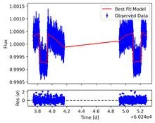
Every 3.97 days, the disk of the star TOI-1080 dims slightly. The shadow lasts a few hours — a planet passing in front of its star, like a fly in front of a lamp. Such 'eclipses' are caught by the TESS space telescope, which watches thousands of stars at once.
The weather on the next street can differ from yours: cooler by the river, hotter over asphalt, windier between buildings. A regular forecast misses this: its grid cell is the size of a city, not a backyard.
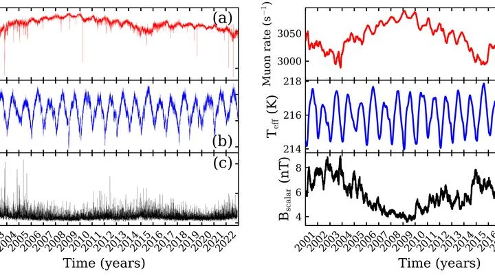
Every second, invisible particles from space, cosmic rays, strike Earth's atmosphere. Colliding with air molecules, they produce showers of secondary particles, among which muons are especially abundant. A muon is a heavy cousin of the electron that lives only a couple of microseconds but still manages to reach the ground.
A solar flare is like a shot from a giant cannon: it blasts a stream of charged particles into space. When that stream reaches Earth, the planet's magnetic field usually deflects it, but in polar regions, particles penetrate the atmosphere.
An ice core from Antarctica is a time machine that recorded the climate for 130,000 years straight, year after year, with no gaps. Air bubbles trapped in the ice preserve the carbon dioxide of those ancient eras.
The dayside of WASP-121b is scorching at 2358 kelvins, hotter than the surface of many stars. Here, in perpetual light, the atmosphere does not just boil: it melts rock and turns it into gas. But not all gas stays gaseous. Some condenses into clouds, and those clouds hide titanium the way a trap hides its prey.
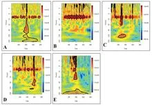
The ocean hums like a crowded hall: in one corner, voices argue about decades; in another, about years; in a third, about the changing seasons. To pick apart these voices, climatologists used to rely on filters they tuned themselves, letting through only slow waves or only fast ones. But the Pacific plays by its own rules: a warm patch off the coast of Peru can be a brief spike or part of a long-term rearrangement.
A translator that learned the grammar of the wind, not just the vocabulary. The wind blows over the Pacific, and the water responds with waves, currents, and upwellings of cold depths. The KIST-Ocean neural network was taught not just to memorize how the ocean looked yesterday, but to understand why it will become what it is tomorrow.
A translator at a high-stakes negotiation doesn't just render words quickly; they make sure the meaning doesn't get lost. CAMulator does the same: it takes the complex climate model CAM6 and translates it into the language of a neural network that runs hundreds of times faster, without losing the physical essence.
An interpreter in a conference room hears not just words but intonations, pauses, and gestures. From these cues, they anticipate where the conversation will turn. The Pacific climate speaks the language of wind, heat, and currents, and PTSTnet listens like an experienced simultaneous interpreter, grasping the grammar of ocean and atmosphere.
In the hall, fifty sages confer, each observing the ocean in their own way. One listens to surface temperature, another to the wind, a third to how heat hides in the depths. Their judgments often contradict each other, but there is an elder who knows which of them to trust more.
In a meeting room, an interpreter listens not only to the speaker but to the entire buzz of voices, catching who is looking at whom and who falls silent before an important remark. That's how SEA-ViT reads the ocean: it sees not isolated points from buoys but the whole current field at once, like a single conversation of water.
Imagine an interpreter in a huge hall who hears not only the person next to them but also a whisper in the far corner, and from those fragments reconstructs the entire conversation. That's how the CAS-Canglong neural network works: it picks up connections between pressure, wind, and heat across the whole planet and uses them to predict what the ocean will look like three months from now.
An artist painting the ocean does not limit themselves to two colors: warm and cold. Likewise, climatologists studying El Niño increasingly speak of a whole palette of shades. El Niño is a warm current off the coast of Peru that, every few years, alters weather across the planet. Its counterpart, La Niña, brings cold.
Water remembers. Every current, every eddy, every degree of temperature in the ocean's depths does not vanish without a trace; it leaves a mark that can be read. But until recently, that mark was read only by bulky physical models that spent weeks on supercomputers and still got the details wrong.